IMAGES TAKEN NEAR TO
Cow Wath Close, SCARBOROUGH, YO12 6UR
Introduction
This page details the photographs taken nearby to Cow Wath Close, YO12 6UR by members of the Geograph project.
The Geograph project started in 2005 with the aim of publishing, organising and preserving representative images for every square kilometre of Great Britain, Ireland and the Isle of Man.

There are currently over 7.5m images from over14,400 individuals and you can help contribute to the project by visiting https://www.geograph.org.uk
Image Map
Images are licensed for reuse under creativecommons.org/licenses/by-sa/2.0
Notes
- Clicking on the map will re-center to the selected point.
- The higher the marker number, the further away the image location is from the centre of the postcode.
Image Listing (39 Images Found)
Images are licensed for reuse under creativecommons.org/licenses/by-sa/2.0
Image
Details
Distance
1
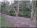
Scalby Beck
View of Scalby Beck and old pipe bridge.
Image: © Darren Haddock
Taken: Unknown
0.08 miles
5
Bridge over Scalby Beck
On the route of a now dismantled rail line (Scarborough to Ravenscar and Whitby), now a walking and cycling route into the town.
Image: © Peter Barr
Taken: 15 Sep 2013
0.14 miles
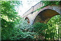
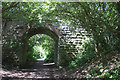
7
The old railway line crosses the viaduct over Scalby Beck (Sea Cut)
Image: © N Chadwick
Taken: 4 Jun 2010
0.14 miles
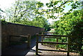
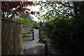
9
Old railway walls at Scalby Beck
These walls on either side of the path look like some remaining bits of the old railway infrastructure. Nothing remains of Scalby station itself but there is a reference to the viaduct from where this picture was taken along with old maps and photos on this site http://www.disused-stations.org.uk/s/scalby/index.shtml
Image: © Robert Eva
Taken: 16 May 2019
0.15 miles
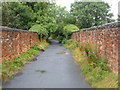
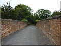
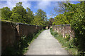
10
Footpath at the end of Chichester Close
Much of the old railway route (the cinder track) disappears under new housing development at Scalby. Here is where it can be found again.
Image: © Robert Eva
Taken: 16 May 2019
0.15 miles