IMAGES TAKEN NEAR TO
Danes Dyke, SCARBOROUGH, YO12 6UG
Introduction
This page details the photographs taken nearby to Danes Dyke, YO12 6UG by members of the Geograph project.
The Geograph project started in 2005 with the aim of publishing, organising and preserving representative images for every square kilometre of Great Britain, Ireland and the Isle of Man.

There are currently over 7.5m images from over14,400 individuals and you can help contribute to the project by visiting https://www.geograph.org.uk
Image Map
Images are licensed for reuse under creativecommons.org/licenses/by-sa/2.0
Notes
- Clicking on the map will re-center to the selected point.
- The higher the marker number, the further away the image location is from the centre of the postcode.
Image Listing (61 Images Found)
Images are licensed for reuse under creativecommons.org/licenses/by-sa/2.0
Image
Details
Distance
4
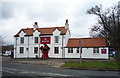
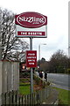
The Rosette public house, Newby
On Hackness Road.
Image: © JThomas
Taken: 27 Feb 2016
0.12 miles
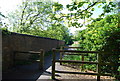
7
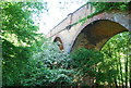
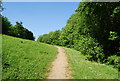
Bridge over Scalby Beck
On the route of a now dismantled rail line (Scarborough to Ravenscar and Whitby), now a walking and cycling route into the town.
Image: © Peter Barr
Taken: 15 Sep 2013
0.12 miles
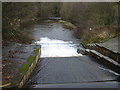
9
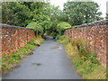
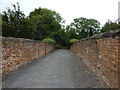
The old railway line crosses the viaduct over Scalby Beck (Sea Cut)
Image: © N Chadwick
Taken: 4 Jun 2010
0.14 miles