IMAGES TAKEN NEAR TO
Hillcrest Avenue, SCARBOROUGH, YO12 6RQ
Introduction
This page details the photographs taken nearby to Hillcrest Avenue, YO12 6RQ by members of the Geograph project.
The Geograph project started in 2005 with the aim of publishing, organising and preserving representative images for every square kilometre of Great Britain, Ireland and the Isle of Man.

There are currently over 7.5m images from over14,400 individuals and you can help contribute to the project by visiting https://www.geograph.org.uk
Image Map (Loading...)


Getting Data...Please wait
Leaflet Map data © OpenStreetMap
Images are licensed for reuse under creativecommons.org/licenses/by-sa/2.0
Notes
- Clicking on the map will re-center to the selected point.
- The higher the marker number, the further away the image location is from the centre of the postcode.
Image Listing (64 Images Found)
Images are licensed for reuse under creativecommons.org/licenses/by-sa/2.0
Image
Details
Distance
2
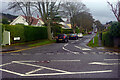
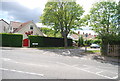
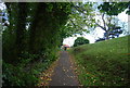
Hillcrest Avenues, Scalby
Leafy Hillcrest Avenue leads off Burniston Road in the northern suburbs of Scarborough. Many of the houses overlook North Cliff Golf Course.
Image: © Stephen McKay
Taken: 24 Dec 2021
0.08 miles
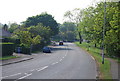
8
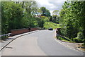
Footpath along Burniston Rd
This path cuts the corner near Scalby Beck.
Image: © N Chadwick
Taken: 30 May 2010
0.11 miles