IMAGES TAKEN NEAR TO
Scholes Park Cliff, SCARBOROUGH, YO12 6RF
Introduction
This page details the photographs taken nearby to Scholes Park Cliff, YO12 6RF by members of the Geograph project.
The Geograph project started in 2005 with the aim of publishing, organising and preserving representative images for every square kilometre of Great Britain, Ireland and the Isle of Man.

There are currently over 7.5m images from over14,400 individuals and you can help contribute to the project by visiting https://www.geograph.org.uk
Image Map (Loading...)


Getting Data...Please wait
Leaflet Map data © OpenStreetMap
Images are licensed for reuse under creativecommons.org/licenses/by-sa/2.0
Notes
- Clicking on the map will re-center to the selected point.
- The higher the marker number, the further away the image location is from the centre of the postcode.
Image Listing (69 Images Found)
Images are licensed for reuse under creativecommons.org/licenses/by-sa/2.0
Image
Details
Distance
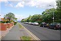
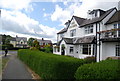
4
Scholes Park Road
Looking east from Burniston Road (A165).
Image: © JThomas
Taken: 27 Feb 2016
0.13 miles
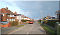
5
Captain's View, Scalby Mills Rd
A modern apartment development.
Image: © N Chadwick
Taken: 30 May 2010
0.13 miles
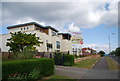
7
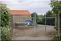
Whitby Road Bridge Sewage Pumping Station
Image: © N Chadwick
Taken: 30 May 2010
0.13 miles
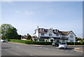
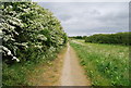
8
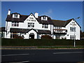
The Ivanhoe public house, Scalby.
The Ivanhoe public house, no better place to be in Scarborough for a good Sunday lunch!.
Image: © Tracey Anne Hartley
Taken: 18 Oct 2009
0.14 miles