IMAGES TAKEN NEAR TO
North Cliff Gardens, SCARBOROUGH, YO12 6PR
Introduction
This page details the photographs taken nearby to North Cliff Gardens, YO12 6PR by members of the Geograph project.
The Geograph project started in 2005 with the aim of publishing, organising and preserving representative images for every square kilometre of Great Britain, Ireland and the Isle of Man.

There are currently over 7.5m images from over14,400 individuals and you can help contribute to the project by visiting https://www.geograph.org.uk
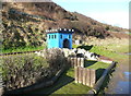
Image Map (Loading...)


Getting Data...Please wait
Leaflet Map data © OpenStreetMap
Images are licensed for reuse under creativecommons.org/licenses/by-sa/2.0
Notes
- Clicking on the map will re-center to the selected point.
- The higher the marker number, the further away the image location is from the centre of the postcode.
Image Listing (135 Images Found)
Images are licensed for reuse under creativecommons.org/licenses/by-sa/2.0
Image
Details
Distance
1
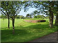
Pillbox alongside North Cliff Avenue, Scalby
This seemingly incongruous structure, which is set into the edge of North Cliff Golf Course, seems out of place until you look at old-maps to see that it is next to the former Burniston Barracks (Royal Tank Corps). The barracks have long since been re-developed for housing, but the pillbox has been bricked up and left in place. See also Image
Image: © John S Turner
Taken: 18 Jun 2016
0.05 miles
2
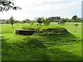
Pillbox alongside North Cliff Avenue, Scalby #2
This seemingly incongruous structure, which is set into the edge of North Cliff Golf Course, seems out of place until you look at old-maps to see that it is next to the former Burniston Barracks (Royal Tank Corps). The barracks have long since been re-developed for housing, but the pillbox has been bricked up and left in place. See also Image
Image: © John S Turner
Taken: 18 Jun 2016
0.05 miles
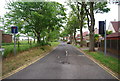
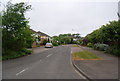
4
North Cliff Avenue and North Cliff Golf Course
North Cliff Avenue from Burniston Road, with the beautifully manicured North Cliff Golf Course behind.
Image: © John S Turner
Taken: 18 Jun 2016
0.14 miles

6
The northern end of the crazy golf course, Scarborough
The small castle is the shelter for the gnome, whose task is to keep the course tidy and watch out for people bringing their own clubs and balls and sneaking onto the course without paying.
Image: © Humphrey Bolton
Taken: 5 Jan 2017
0.14 miles
7
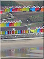
Holiday chalets, North Bay, Scarborough
These are some of the holiday chalets in North Bay which form part of Scarborough Borough Council's regeneration project 'The Sands' from the grounds of Scarborough Castle. The vibrant colours glowed across the chilly sands on a grey February day.
Image: © Hazel Marlor
Taken: 24 Feb 2008
0.14 miles
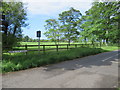
9
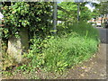
Gatepost at the corner of North Cliff Avenue and Burniston Road
This old gatepost is at the corner of North Cliff Avenue and Burniston Avenue and there is an Ordnance bench mark on the right-hand face - Image
Image: © John S Turner
Taken: 18 Jun 2016
0.14 miles
10
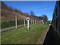
Whistle board on the North Bay Railway
The W sign reminds drivers to whistle as they approach the pedestrian level crossing. As the speed of trains is under 10mph, the sign only needs to be about 20 metres before the crossing.
Image: © Stephen Craven
Taken: 25 Mar 2017
0.14 miles