IMAGES TAKEN NEAR TO
North Leas Avenue, SCARBOROUGH, YO12 6LJ
Introduction
This page details the photographs taken nearby to North Leas Avenue, YO12 6LJ by members of the Geograph project.
The Geograph project started in 2005 with the aim of publishing, organising and preserving representative images for every square kilometre of Great Britain, Ireland and the Isle of Man.

There are currently over 7.5m images from over14,400 individuals and you can help contribute to the project by visiting https://www.geograph.org.uk
Image Map
Images are licensed for reuse under creativecommons.org/licenses/by-sa/2.0
Notes
- Clicking on the map will re-center to the selected point.
- The higher the marker number, the further away the image location is from the centre of the postcode.
Image Listing (58 Images Found)
Images are licensed for reuse under creativecommons.org/licenses/by-sa/2.0
Image
Details
Distance
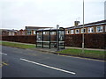
4
Bus stop outside school on North Leas Avenue
Image: © JThomas
Taken: 20 Feb 2016
0.11 miles
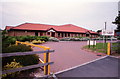
9
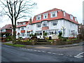
The Ryndle Court Hotel, Scarborough
On Northstead Manor Drive.
Image: © JThomas
Taken: 20 Feb 2016
0.14 miles
10
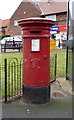
Victorian postbox on North Leas Avenue, Scarborough
Postbox No. YO12 81.
See Image] for cypher.
See Image] for detail.
See Image] , Image] and Image] for context.
Image: © JThomas
Taken: 20 Feb 2016
0.15 miles