IMAGES TAKEN NEAR TO
Irton Moor, SCARBOROUGH, YO12 5TQ
Introduction
This page details the photographs taken nearby to Irton Moor, YO12 5TQ by members of the Geograph project.
The Geograph project started in 2005 with the aim of publishing, organising and preserving representative images for every square kilometre of Great Britain, Ireland and the Isle of Man.

There are currently over 7.5m images from over14,400 individuals and you can help contribute to the project by visiting https://www.geograph.org.uk
Image Map
Images are licensed for reuse under creativecommons.org/licenses/by-sa/2.0
Notes
- Clicking on the map will re-center to the selected point.
- The higher the marker number, the further away the image location is from the centre of the postcode.
Image Listing (7 Images Found)
Images are licensed for reuse under creativecommons.org/licenses/by-sa/2.0
Image
Details
Distance
1
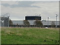
GCHQ Scarborough
GCHQ Scarborough is a satellite ground station located on Irton Moor, on the outskirts of Scarborough operated by the British signals intelligence service.
Image: © Neil Theasby
Taken: 8 Oct 2017
0.03 miles
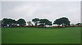
2
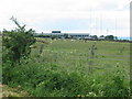
An establishment on Irton Moor known locally as the wireless station
Image: © Phil Catterall
Taken: 23 Jun 2006
0.05 miles
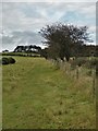
4
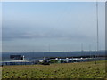
Aerials, Irton Moor
Part of the wireless station known as 'GCHQ Scarborough'. Apparently it is a Composite Signals Organisation (CSO) station. Box Hill Farm in the distance (Image).
Image: © Mick Garratt
Taken: 5 Mar 2010
0.12 miles
5
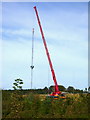
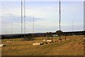
Aerial masts and crane near GCHQ Scarborough
A major antenna engineering exercise was taking place on 18/09/07
Image: © Phil Catterall
Taken: 18 Sep 2007
0.18 miles
7
The path to Seamer Beacon
East of Riggs Head
Image: © Neil Theasby
Taken: 8 Oct 2017
0.21 miles