IMAGES TAKEN NEAR TO
Pegasus Close, SCARBOROUGH, YO12 5AP
Introduction
This page details the photographs taken nearby to Pegasus Close, YO12 5AP by members of the Geograph project.
The Geograph project started in 2005 with the aim of publishing, organising and preserving representative images for every square kilometre of Great Britain, Ireland and the Isle of Man.

There are currently over 7.5m images from over14,400 individuals and you can help contribute to the project by visiting https://www.geograph.org.uk
Image Map
Images are licensed for reuse under creativecommons.org/licenses/by-sa/2.0
Notes
- Clicking on the map will re-center to the selected point.
- The higher the marker number, the further away the image location is from the centre of the postcode.
Image Listing (8 Images Found)
Images are licensed for reuse under creativecommons.org/licenses/by-sa/2.0
Image
Details
Distance
2
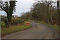
Lady Edith's Drive
Dropping down into Throxenby.
Image: © Mick Garratt
Taken: 5 Mar 2010
0.21 miles
4

Lady Edith's Drive
Lady Edith's Drive near Yorkshire Coast College.
(The road is named after Lady Edith Sitwell.)
Image: © Phil Catterall
Taken: 24 Oct 2006
0.22 miles
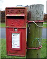
5
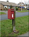
Elizabeth II postbox on Moor Lane, Scarborough
Image: © JThomas
Taken: 27 Feb 2016
0.23 miles
6
Close up, Elizabeth II postbox on Moor Lane, Scarborough
Postbox No. YO12 198.
See Image] for postbox.
Image: © JThomas
Taken: 27 Feb 2016
0.23 miles
7
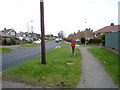
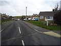
Moor Lane, Scarborough
Looking north showing position of Postbox No. YO12 198.
See Image] for postbox.
Image: © JThomas
Taken: 27 Feb 2016
0.23 miles
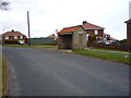
8
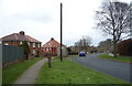
Moor Lane, Scarborough
Looking south showing position of Postbox No. YO12 198.
See Image] for postbox.
Image: © JThomas
Taken: 27 Feb 2016
0.23 miles