IMAGES TAKEN NEAR TO
Welbourn Drive, SCARBOROUGH, YO12 4RP
Introduction
This page details the photographs taken nearby to Welbourn Drive, YO12 4RP by members of the Geograph project.
The Geograph project started in 2005 with the aim of publishing, organising and preserving representative images for every square kilometre of Great Britain, Ireland and the Isle of Man.

There are currently over 7.5m images from over14,400 individuals and you can help contribute to the project by visiting https://www.geograph.org.uk
Image Map
Images are licensed for reuse under creativecommons.org/licenses/by-sa/2.0
Notes
- Clicking on the map will re-center to the selected point.
- The higher the marker number, the further away the image location is from the centre of the postcode.
Image Listing (29 Images Found)
Images are licensed for reuse under creativecommons.org/licenses/by-sa/2.0
Image
Details
Distance
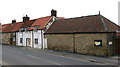
8
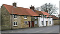
Cottages on Seamer Main Street
The second cottage from the left is called Maison Militaire Bower Cottage; a military connection?
Image: © David Rogers
Taken: 13 Mar 2009
0.19 miles
9
Seamer Church Room
Currently undergoing renovation or conversion.
Image: © David Rogers
Taken: 13 Mar 2009
0.20 miles
10
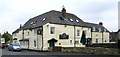
Londesborough Arms Seamer.
Located on Seamer's Main Street.
Image: © David Rogers
Taken: 13 Mar 2009
0.20 miles