IMAGES TAKEN NEAR TO
SCARBOROUGH, YO11 3JY
Introduction
This page details the photographs taken nearby to YO11 3JY by members of the Geograph project.
The Geograph project started in 2005 with the aim of publishing, organising and preserving representative images for every square kilometre of Great Britain, Ireland and the Isle of Man.

There are currently over 7.5m images from over14,400 individuals and you can help contribute to the project by visiting https://www.geograph.org.uk
Image Map
Images are licensed for reuse under creativecommons.org/licenses/by-sa/2.0
Notes
- Clicking on the map will re-center to the selected point.
- The higher the marker number, the further away the image location is from the centre of the postcode.
Image Listing (36 Images Found)
Images are licensed for reuse under creativecommons.org/licenses/by-sa/2.0
Image
Details
Distance
2

Footpath near Osgodby
Looking towards the new A165 road.
Image: © JThomas
Taken: 13 Jul 2009
0.05 miles
4
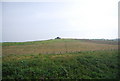
View from the Footpath near Osgodby
Looking towards Scarborough.
Image: © JThomas
Taken: 13 Jul 2009
0.09 miles
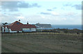
5
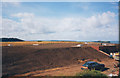
New service reservoir, Osgodby
The newly completed service reservoir at Osgodby. A twin compartment, half-buried concrete one which replaced the old single compartment shallow reservoir.
The replacement was part of a project improving the water supply in south Scarborough. It involved replacing three old reservoirs. Two of them on Olivers Mount were to be replaced with larger ones on the same sites.
The one at Osgodby was on a greenfield site, and was built adjacent to the old reservoir so the old one could stay in use until the new one was commissioned. The old reservoir was a simple earth embankment, originally open to the air but with a later roof structure, supported (if I recall correctly) on steel trusses. The photo here was taken from the roof of the old reservoir before the roof of the old reservoir was then removed and the hole filled in to ground level.
Water is supplied from a borehole pumping station at Irton Image
Image: © Stephen Craven
Taken: 29 Jul 1998
0.09 miles
6
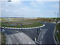
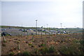
The New A165 at Osgodby
Not yet on the map the newly built A165, the old road through Cayton Bay way over to the right and at some point in the future will fall victim to erosion and collapse into the North Sea. Left at the roundabout to Osgodby, right to Park and Ride, straight on for Scarborough.
Image: © Martin Dawes
Taken: 11 Jul 2009
0.10 miles
7
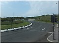
Osgodby Roundabout
Looking northeasterly towards the road which leads to the Park and Ride car park.
Image: © Barbara Carr
Taken: 21 Jun 2013
0.11 miles
8
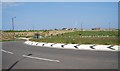
Roundabout on the new Osgodby bypass (A165)
Image: © N Chadwick
Taken: 2 Jun 2010
0.15 miles
9
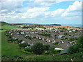
A house with a view
Near Osgodby, with views over Scarborough's South Bay and the changing moods of the North Sea.
Image: © Chris Yeates
Taken: 26 Dec 2005
0.16 miles