IMAGES TAKEN NEAR TO
Gouldings Close, SCARBOROUGH, YO11 3HD
Introduction
This page details the photographs taken nearby to Gouldings Close, YO11 3HD by members of the Geograph project.
The Geograph project started in 2005 with the aim of publishing, organising and preserving representative images for every square kilometre of Great Britain, Ireland and the Isle of Man.

There are currently over 7.5m images from over14,400 individuals and you can help contribute to the project by visiting https://www.geograph.org.uk
Image Map
Images are licensed for reuse under creativecommons.org/licenses/by-sa/2.0
Notes
- Clicking on the map will re-center to the selected point.
- The higher the marker number, the further away the image location is from the centre of the postcode.
Image Listing (12 Images Found)
Images are licensed for reuse under creativecommons.org/licenses/by-sa/2.0
Image
Details
Distance

4
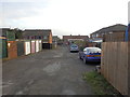
Garages and Access Road off Overdale
Image: © Darren Haddock
Taken: 10 Nov 2014
0.15 miles
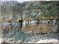
6
Deep Dale
Sandstone cliffs on the west side of the Deep Dale valley at Eastfield, south of Scarborough.
Image: © Paul Glazzard
Taken: 15 Aug 2008
0.18 miles
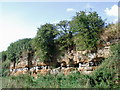
7
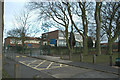
Overdale Primary School, Eastfield
Typical 1950s building, with large south-facing windows. I remember as a child the class watching a cereal field being combined beyond the beech trees - now it's just a big housing estate.
Image: © Chris Yeates
Taken: 26 Dec 2005
0.19 miles