
IMAGES TAKEN NEAR TO
Oriel Crescent, SCARBOROUGH, YO11 2SY
Introduction
This page details the photographs taken nearby to Oriel Crescent, YO11 2SY by members of the Geograph project.
The Geograph project started in 2005 with the aim of publishing, organising and preserving representative images for every square kilometre of Great Britain, Ireland and the Isle of Man.

There are currently over 7.5m images from over14,400 individuals and you can help contribute to the project by visiting https://www.geograph.org.uk
Image Map
Images are licensed for reuse under creativecommons.org/licenses/by-sa/2.0
Notes
- Clicking on the map will re-center to the selected point.
- The higher the marker number, the further away the image location is from the centre of the postcode.
Image Listing (132 Images Found)
Images are licensed for reuse under creativecommons.org/licenses/by-sa/2.0
Image
Details
Distance
1
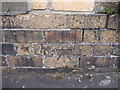
Bench mark between 2-3 Oriel Crescent, Scarborough
This bench mark is on the old low brick wall between #2-3 Oriel Crescent, and opposite the Oriel Cricket and Recreation Ground. The brick pillar above the mark has been rebuilt using modern bricks, but the low wall hasn't changed. See also Image
Image: © John S Turner
Taken: 11 May 2010
0.02 miles
2
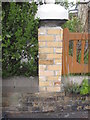
Modern brick pier between #2-3 Oriel Crescent
This modern brick pier stands on top of a much older wall between #2-3 Oriel Crescent. There is an Ordnance Survey bench mark on the old wall below - Image
Image: © John S Turner
Taken: 11 May 2010
0.02 miles
3

Bench mark in Oriel Crescent
This bench mark is on the wall surrounding the cricket ground in the centre of Oriel Crescent. See also Image The mark is recorded on the bench mark database: http://www.bench-marks.org.uk/bm41427
Image: © John S Turner
Taken: 4 Feb 2012
0.03 miles
4
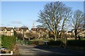
Oriel cricket ground and Oriel Crescent
Looking down Oriel Bank across Oriel cricket ground towards Oriel Crescent. Oriel Crescent was laid out about 1872 and house built over a thirty year period. As with many developments in this part of Scarborough it is laid out as a crescent with a green central area, in this case a particularly large one that is used as a cricket ground. The houses are large semi-detached villas. In the background the tower of the former Holy Trinity Church
Image: © Christopher Hall
Taken: 6 Dec 2013
0.03 miles
6
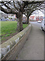
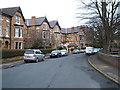
Trees and a wall in Oriel Crescent
The large green area on the left in Oriel Crescent is used as a cricket ground, and there is a bench mark on the wall just in front of the camera - Image
Image: © John S Turner
Taken: 4 Feb 2012
0.04 miles
7
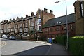
Victoria Memorial Hall, Westbourne Grove
This is the point where Westbourne Grove makes a sharp left hand bend. On the right can be seen the apsidal end of Holy Trinity Church opened in 1880.The terrace of large buff brick houses is circa 1875-80.Between the two is the hall for Holy Trinity called Victoria Memorial Hall designed in 1902 by Demaine & Brierley of York and opened the following year. It was intended to be used as a gymnasium and drill room for the Church Lads Brigade and had space for 400 people. It is now residential.
Holy trinity can also be seen in Image
Image: © Christopher Hall
Taken: 8 Apr 2014
0.05 miles

9

Plaque on Victoria Memorial Hall
Detail of a marble commemorative plaque on the hall shown in Image
Image: © Christopher Hall
Taken: 11 Dec 2013
0.05 miles
10

Westbourne Road
Westbourne Road consists of very large late Victorian Villas. in the background behind the red car is Oriel Cricket ground also shown in Image In the distance the scarp slope of Falsgrave Moor with a caravan park on it.
Image: © Christopher Hall
Taken: 8 Apr 2014
0.05 miles