IMAGES TAKEN NEAR TO
Cromwell Road, SCARBOROUGH, YO11 2DR
Introduction
This page details the photographs taken nearby to Cromwell Road, YO11 2DR by members of the Geograph project.
The Geograph project started in 2005 with the aim of publishing, organising and preserving representative images for every square kilometre of Great Britain, Ireland and the Isle of Man.

There are currently over 7.5m images from over14,400 individuals and you can help contribute to the project by visiting https://www.geograph.org.uk
Image Map
Images are licensed for reuse under creativecommons.org/licenses/by-sa/2.0
Notes
- Clicking on the map will re-center to the selected point.
- The higher the marker number, the further away the image location is from the centre of the postcode.
Image Listing (236 Images Found)
Images are licensed for reuse under creativecommons.org/licenses/by-sa/2.0
Image
Details
Distance
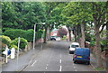
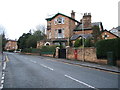
2
Cromwell Road, Scarborough
Looking uphill from Valley Road.
Image: © JThomas
Taken: 20 Feb 2016
0.05 miles
4
George VI postbox on Westbourne Grove, Scarborough
Image: © JThomas
Taken: 20 Feb 2016
0.07 miles
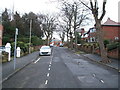
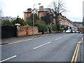
5
Westbourne Grove, Scarborough
Looking east showing position of Postbox No. YO11 163.
See Image] for postbox.
Image: © JThomas
Taken: 20 Feb 2016
0.07 miles
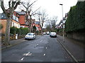
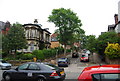
6
Westbourne Grove, Scarborough
Looking west showing position of Postbox No. YO11 163.
See Image] for postbox.
Image: © JThomas
Taken: 20 Feb 2016
0.07 miles
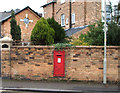
7
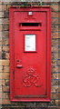
Close up, George VI postbox on Westbourne Grove, Scarborough
Postbox No. YO11 163.
See Image] for postbox.
Image: © JThomas
Taken: 20 Feb 2016
0.07 miles
9
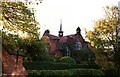
Former St Martins School
This is the former St Martin's C of E junior school on Royal Avenue. The school was opened in 1898 and designed by the Scarborough Architects Messrs Tugwell (Frank & Sydney Tugwell) in the Arts & Crafts style of which Frank Tugwell was a fine regional exponent.
The photograph was taken in October 1988 just before the demolition of the school.
Image: © Christopher Hall
Taken: Unknown
0.07 miles
10
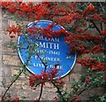
Blue plaque on 41 Westbourne Grove
This blue plaque is to Harry W Smith 1867 to 1944 who was Borough Engineer 1897-to 1933. His works included Peasholm Park and Glen, Northstead Manor Gardens, the miniature railway, the Open Air Theatre, the South Bay Pool etc etc.
Image: © Christopher Hall
Taken: 27 Nov 2013
0.08 miles