IMAGES TAKEN NEAR TO
Alga Terrace, SCARBOROUGH, YO11 2DF
Introduction
This page details the photographs taken nearby to Alga Terrace, YO11 2DF by members of the Geograph project.
The Geograph project started in 2005 with the aim of publishing, organising and preserving representative images for every square kilometre of Great Britain, Ireland and the Isle of Man.

There are currently over 7.5m images from over14,400 individuals and you can help contribute to the project by visiting https://www.geograph.org.uk
Image Map
Images are licensed for reuse under creativecommons.org/licenses/by-sa/2.0
Notes
- Clicking on the map will re-center to the selected point.
- The higher the marker number, the further away the image location is from the centre of the postcode.
Image Listing (468 Images Found)
Images are licensed for reuse under creativecommons.org/licenses/by-sa/2.0
Image
Details
Distance
1
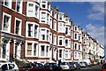
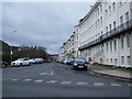
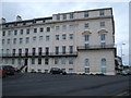
Prince of Wales Terrace
This part of Prince of Wales Terrace dates from about 1865. This is a very robust piece of 19th century architecture with string rhythm due to the bay windows. The stucco building at the far end started life as a series of houses about 1845, became the Prince of Wales Hotel and is now flats. there are two window cleaners working with very long poles to reach third floor windows
Image: © Christopher Hall
Taken: 8 Apr 2014
0.02 miles
2
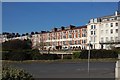
Hotel on square
Stayed here during geological weekend
Image: © Stephen Darlington
Taken: 14 Mar 2011
0.02 miles
3
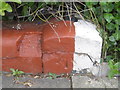
Bench mark outside the Prince of Wales Apartments
This damaged Ordnance Survey bench mark is on the low wall in front of the Prince of Wales Apartments. It seems to date to at least 1891 when the building was the Prince of Wales Hotel. See also Image
Image: © John S Turner
Taken: 11 May 2010
0.02 miles
4
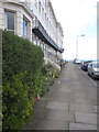
Prince of Wales Apartments, Scarborough
Looking along the front of the Prince of Wales Apartments in Prince of Wales Terrace. The blue line at the end of the road is in fact the sea, so the apartments have great sea views. The building on this site used to be the Prince of Wales Hotel, but according to one website it was damaged in WW1 on 13th December 1914. On the left, where the apartments meet Red Lea, there is a low red/white garden wall junction with an Ordnance Survey bench mark - Image This mark seems to date to at least 1891.
Image: © John S Turner
Taken: 11 May 2010
0.02 miles
5
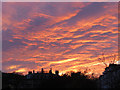
Amazing sunset above Scarborough
After a wet day in Scarborough we were treated to a magnificent sunset above the Prince of Wales Gardens.
Image: © John S Turner
Taken: 18 Nov 2013
0.03 miles
7
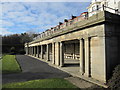
Prince of Wales Gardens shelter
The shelter in the Prince of Wales Gardens below the Prince of Wales Terrace.
Image: © John S Turner
Taken: 27 Jan 2011
0.04 miles
8
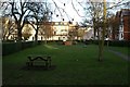
St Martin's Square
St Martin's Square is one of Scarborough's town squares which would have originally been the private gardens for the adjacent houses. It is now a public garden. The buildings in Image are behind the camera.
Image: © Christopher Hall
Taken: 1 Feb 2014
0.04 miles
9
Houses on Prince of Wales Terrace, Scarborough
Image: © JThomas
Taken: 20 Feb 2016
0.04 miles
10
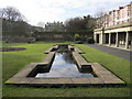
Prince of Wales Gardens ornamental pool
Looking southwest along the ornamental pool in the Prince of Wales Gardens. The shelter is on the right Image
Image: © John S Turner
Taken: 27 Jan 2011
0.05 miles