IMAGES TAKEN NEAR TO
Crown Crescent, SCARBOROUGH, YO11 2BJ
Introduction
This page details the photographs taken nearby to Crown Crescent, YO11 2BJ by members of the Geograph project.
The Geograph project started in 2005 with the aim of publishing, organising and preserving representative images for every square kilometre of Great Britain, Ireland and the Isle of Man.

There are currently over 7.5m images from over14,400 individuals and you can help contribute to the project by visiting https://www.geograph.org.uk
Image Map
Images are licensed for reuse under creativecommons.org/licenses/by-sa/2.0
Notes
- Clicking on the map will re-center to the selected point.
- The higher the marker number, the further away the image location is from the centre of the postcode.
Image Listing (510 Images Found)
Images are licensed for reuse under creativecommons.org/licenses/by-sa/2.0
Image
Details
Distance
1
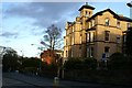
Ramshill Road junction with Valley Bridge Road
Ramshill road comes up from the Valley, makes a junction with Valley Bridge Road and then passes in front of the camera. Belmont road goes off in front of the red brick building. The winter sunshine is nicely catching the buff Scarborough brick of the Italianate villa of circa 1866.
Image: © Christopher Hall
Taken: 1 Feb 2014
0.02 miles
2
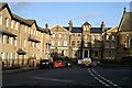
Grosvenor Road
This short length of Grosvenor Road links through to Ramshill Road which crosses in front of the large terrace facing the camera. On the left a block of flats is on the site of the former Cambridge Hotel while on the right the end of St Andrews church can be seen. The terrace forming the focal point is of about 1860 and displays Italianate features. It is built in a distinctive greyish buff brick produced in Scarborough at that time
Image: © Christopher Hall
Taken: 1 Feb 2014
0.03 miles
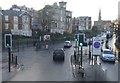
4
Traffic lights at the end of Valley Bridge
Image: © N Chadwick
Taken: 2 Jun 2010
0.04 miles
5
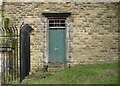
South west abutment of Valley Bridge
The abutments of Valley Bridge are massive rock faced stone construction. The south west abutment has this door in it, it is thought that there is a gardener's store in a void within the abutment. The setting of the bridge is shown in Image
Image: © Christopher Hall
Taken: 9 Feb 2014
0.05 miles
7
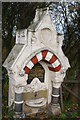
Scarborough drinking fountains; The Williamson Fountain
Public drinking fountains are expressions of later C19 charitable provision. The Metropolitan Drinking Fountain and Cattle Trough Association had been established in London by Samuel Gurney an MP and philanthropist and Edward Thomas Wakefield, a barrister, in 1859 to provide free drinking water. Originally called the Metropolitan Free Drinking Fountain Association it changed its name to include cattle troughs in 1867, to also support animal welfare. The objective of the Association was the provision of clean water for the working classes and for animals. This initiative in London was followed regionally and Scarborough, as a rapidly developing sea-side resort especially frequented by the middle classes and entrepreneurs of industrial West Yorkshire, was no exception in terms of both public drinking fountains and horse troughs.
This is the ‘Williamson Fountain’ located at the south-east end of Valley Bridge and dedicated to the leading campaigner for the construction of the Valley Bridge. The inscription on it reads ‘A sister’s tribute to the memory of Robert Willamson through whose suggestion and persevering energy this bridge was erected. He died November MDCCCLXIV’ (1864). Image shows a blue plaque to Williamson and Image a plaque on the bridge.
Image: © Christopher Hall
Taken: 27 Nov 2013
0.05 miles
8
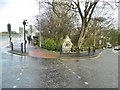
Scarborough, fountain
At the corner of Valley Bridge Road and Ramshill Road; commemorating Robert Williamson (d 1864) who inspired the neighbouring bridge.
Image: © Mike Faherty
Taken: 20 Feb 2018
0.05 miles
9
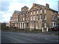
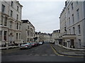
Houses on Ramshill Road (A165), Scarborough
Image: © JThomas
Taken: 13 Feb 2016
0.05 miles
10
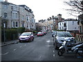
Cambridge Terrace, Scarborough
The car on the left seems to have had a mishap.
Image: © JThomas
Taken: 13 Feb 2016
0.06 miles