IMAGES TAKEN NEAR TO
Graham Close, Paradise, SCARBOROUGH, YO11 1RU
Introduction
This page details the photographs taken nearby to Graham Close, Paradise, YO11 1RU by members of the Geograph project.
The Geograph project started in 2005 with the aim of publishing, organising and preserving representative images for every square kilometre of Great Britain, Ireland and the Isle of Man.

There are currently over 7.5m images from over14,400 individuals and you can help contribute to the project by visiting https://www.geograph.org.uk
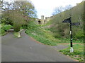
Image Map
Images are licensed for reuse under creativecommons.org/licenses/by-sa/2.0
Notes
- Clicking on the map will re-center to the selected point.
- The higher the marker number, the further away the image location is from the centre of the postcode.
Image Listing (1267 Images Found)
Images are licensed for reuse under creativecommons.org/licenses/by-sa/2.0
Image
Details
Distance

2
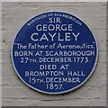
Blue plaque to Sir George Cayley on Paradise House
Blue plaque on Paradise House which commemorates the fact that Sir George Cayley was born in Scarborough, probably in Paradise House,
Image: © Christopher Hall
Taken: 23 Nov 2013
0.03 miles
3

Blue plaque on Paradise House
The present Paradise House is mid 18th century but a house is mentioned here in 1673. Engravings show a rambling Jacobean building pre-dating the present one. In fact, even earlier, the Scarborough House of the Proctor of Citeaux may have been on this site. The plaque celebrates the long nautical associations of the house, which is now flats.
Image: © Christopher Hall
Taken: 23 Nov 2013
0.03 miles
4
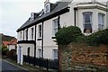
Paradise House, Paradise
Paradise means enclosed monastic garden. This was probably the site of the Scarborough House of the Proctor of Citeaux, hence the name. The present house, which dates from the mid 18th century is probably the third on the site. A house is mentioned here in 1673 but we know from early 18th century engravings that house was in the Jacobean style.
Just beyond the porch are two blue plaques one to Sir George Cayley, just visible, and one below referring to the nautical associations. The house is now flats.
Image: © Christopher Hall
Taken: 23 Nov 2013
0.03 miles
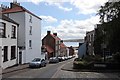
5
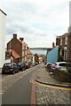
Castlegate, Scarborough
Looking down the steep street which descends (or climbs) the slope between Scarborough's harbour and castle.
Image: © Graham Robson
Taken: 14 Jun 2022
0.03 miles
6
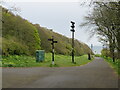
Royal Albert Park, Scarborough
Royal Albert Park lies alongside Scarborough's castle walls, which are visible to the left of the image.
Image: © Malc McDonald
Taken: 30 Apr 2021
0.04 miles
7
Royal Albert Park, Scarborough
Royal Albert Park lies alongside Scarborough's castle walls.
Image: © Malc McDonald
Taken: 30 Apr 2021
0.04 miles
8
Castlegate, Scarborough
Castlegate is in that part of Scarborough described as the Old Town.
See also this photograph by M H Evans:- Image
Image: © Alan Walker
Taken: 16 Jul 2017
0.04 miles
9
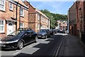
Longwestgate, Scarborough
Longwestgate is in that part of Scarborough described as the Old Town
Ahead is Longwestgate’s junction with Image
See also this photograph by JThomas:- Image
Image: © Alan Walker
Taken: 16 Jul 2017
0.04 miles
10
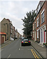
Scarborough: along Longwestgate
Pleasing Grade II listed eighteenth-century houses in the Old Town.
Image: © John Sutton
Taken: 21 Aug 2019
0.04 miles