IMAGES TAKEN NEAR TO
West Sandgate, SCARBOROUGH, YO11 1QL
Introduction
This page details the photographs taken nearby to West Sandgate, YO11 1QL by members of the Geograph project.
The Geograph project started in 2005 with the aim of publishing, organising and preserving representative images for every square kilometre of Great Britain, Ireland and the Isle of Man.

There are currently over 7.5m images from over14,400 individuals and you can help contribute to the project by visiting https://www.geograph.org.uk
Image Map
Images are licensed for reuse under creativecommons.org/licenses/by-sa/2.0
Notes
- Clicking on the map will re-center to the selected point.
- The higher the marker number, the further away the image location is from the centre of the postcode.
Image Listing (1510 Images Found)
Images are licensed for reuse under creativecommons.org/licenses/by-sa/2.0
Image
Details
Distance
1
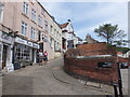
Steep climb to Scarborough Castle
This little lane twists uphill to cross Princess Street into St Mary's Street, where can be found the mediaeval Butter Cross and St Mary's Church, from where Castle Road leads to the castle.
Image: © Barbara Carr
Taken: 17 Jun 2013
0.00 miles
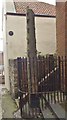
2
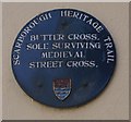
Heritage Trail plaque to the Butter Cross
This plaque is on the back wall of a house on West Sandgate which is immediately adjacent to the Butter Cross.
Image: © Christopher Hall
Taken: 1 Dec 2013
0.00 miles
4
Off Licence on Princess Square, Scarborough
Image: © JThomas
Taken: 13 Feb 2016
0.00 miles
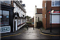
6
The junction of Princess Street and West Sandgate, Scarborough
Image: © habiloid
Taken: 18 Feb 2023
0.00 miles
7
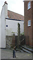
The Butter Cross, West Sandgate, Scarborough
Image: © habiloid
Taken: 21 Feb 2025
0.00 miles
8
Old Central Cross by West Sandgate, Scarborough Parish
The Butter Cross, old shaft and base by the wayside, in parish of Scarborough (Scarborough District), West Sandgate, just South of Princess Street. Tall stone with crocket type leaves running up the angles of the shaft.
Grade I listed. List Entry Number: 1243561
https://historicengland.org.uk/listing/the-list/list-entry/1243561
To be surveyed
Milestone Society National ID: YNSC_SCA
Image: © Milestone Society
Taken: Unknown
0.00 miles
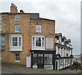
9
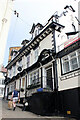
Wilsons, 6 West Sandgate, Scarborough
Grade II Listed building dated 1692 but significantly altered around 1900. Formerly the Leeds Hotel the late 19th or early 20th century restoration was reportedly to a design by Frank A Tugwell. As I can find no West Sandgate in early directories it seems it may have previously been part of St Mary's Street. The only inn or tavern I can find listed in 1823 is the Star and Garter and in 1893 the Leeds Arms but by 1913 we have listed "Bruce Fred, Leeds hotel, St. Mary's street". Between June 2013 and October 2014 it changed from the Leeds Hotel to Wilsons. What had been The Hole in the Wall (Scarborough) Ltd. changed its name to G & T Naylor Pub Co. Ltd. when the current occupants moved here in mid 2018 from the Hole in the Wall.
Image: © Jo and Steve Turner
Taken: 31 May 2021
0.01 miles
10
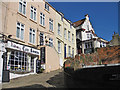
West Sandgate, Scarborough
Narrow street off Eastborough.
Image: © Pauline E
Taken: 27 Feb 2013
0.01 miles