IMAGES TAKEN NEAR TO
Tut Hill, SCARBOROUGH, YO11 1PS
Introduction
This page details the photographs taken nearby to Tut Hill, YO11 1PS by members of the Geograph project.
The Geograph project started in 2005 with the aim of publishing, organising and preserving representative images for every square kilometre of Great Britain, Ireland and the Isle of Man.

There are currently over 7.5m images from over14,400 individuals and you can help contribute to the project by visiting https://www.geograph.org.uk
Image Map
Images are licensed for reuse under creativecommons.org/licenses/by-sa/2.0
Notes
- Clicking on the map will re-center to the selected point.
- The higher the marker number, the further away the image location is from the centre of the postcode.
Image Listing (1603 Images Found)
Images are licensed for reuse under creativecommons.org/licenses/by-sa/2.0
Image
Details
Distance
1
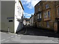
Princess Street (and St Mary Street)
Image: © Michael Steele
Taken: 27 Mar 2010
0.01 miles
3

Princess Street, Scarborough
Nos 18 to 26 on the north side of the street; many of the houses on this street are Grade 2 listed.
Image: © Paul Harrop
Taken: 10 Jun 2015
0.02 miles
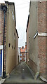
4

Scarborough: Princess Lane
An alley between Princess Street and Tuthill (ahead), photographed on an overcast August morning.
Image: © John Sutton
Taken: 25 Aug 2016
0.02 miles
5

Scarborough: Tuthill
A narrow street in the old town, photographed on a cloudy August morning.
Image: © John Sutton
Taken: 25 Aug 2016
0.02 miles
6
Princess Lane seen from Princess Street, Scarborough
Image: © habiloid
Taken: 18 Feb 2023
0.02 miles
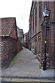
7
The Bolts alongside the former St Thomas's church
This section of The Bolts is alongside the former St Thomas's Church in East Sandgate. The building is now the HQ for Scarborough Sea Cadets 'T.S. Scarborough'.
Image: © John S Turner
Taken: 3 Oct 2009
0.02 miles
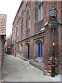
8
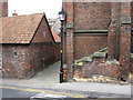
The corner of former St Thomas's church
The corner of the former St Thomas's church where The Bolts alley meets East Sandgate. There is a bench mark on the low wall between the buttresses - Image The former church is now the HQ of Scarborough Sea Cadets, 'T.S. Scarborough'.
Image: © John S Turner
Taken: 3 Oct 2009
0.02 miles
9
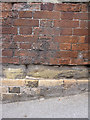
Bench mark on the former St Thomas's church
This bench mark is on a wall between two buttresses alongside East Sandgate. The mark was first recorded on the 1892 Town Plan levelled at 23.46 feet. The former church is now the HQ for Scarborough Sea Cadets. See also Image]
Image: © John S Turner
Taken: 3 Oct 2009
0.03 miles
10
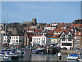
View across Scarborough old harbour
Looking to the old town and parish church.
Image: © Stephen Craven
Taken: 26 Mar 2017
0.03 miles