IMAGES TAKEN NEAR TO
Alma Terrace, YORK, YO10 4DQ
Introduction
This page details the photographs taken nearby to Alma Terrace, YO10 4DQ by members of the Geograph project.
The Geograph project started in 2005 with the aim of publishing, organising and preserving representative images for every square kilometre of Great Britain, Ireland and the Isle of Man.

There are currently over 7.5m images from over14,400 individuals and you can help contribute to the project by visiting https://www.geograph.org.uk
Image Map (Loading...)


Getting Data...Please wait
Leaflet Map data © OpenStreetMap
Images are licensed for reuse under creativecommons.org/licenses/by-sa/2.0
Notes
- Clicking on the map will re-center to the selected point.
- The higher the marker number, the further away the image location is from the centre of the postcode.
Image Listing (186 Images Found)
Images are licensed for reuse under creativecommons.org/licenses/by-sa/2.0
Image
Details
Distance
1
Alma Grove
Alma Grove forms a small square just off the Fulford Road, and is lined with York's earliest council houses dating from 1910.
Image: © Gordon Hatton
Taken: 8 Feb 2009
0.02 miles
2

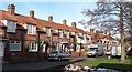
Alma Terrace
Cul-de-sac off Fulford Road leading to the River Ouse. The road itself was first laid out in the 1850s/60s, named after the Battle of Alma of 1854, with the housing at the western end marked on the 1891 1:500 Town Plan. However this nearest terrace, near the junction with Fulford Road, is later, being first shown on the 1909 25 inch map.
Image: © Ian Capper
Taken: 4 Feb 2023
0.02 miles
3
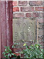
War Department Boundary Stone #9, Pine Alley, off Carey Street
A series of War Department boundary stones once surrounded Holly Croft, the offices of the Command Paymaster off Wenlock Terrace. Most of the stones seem to have been lost to redevelopment, but #8 and #9 survive in 'Pine Alley' off Carey Street, which is the rear perimeter wall of the former Holly Croft. Image
BS #2 can be seen on Streetview in Wenlock Terrace, but I haven't photographed that one.
Inscription reads:-
W.^ D.
B.S.No 9
Surveyed
Milestone Society National ID: YW_WDYORK09em
Image: © John S Turner
Taken: 17 Nov 2017
0.02 miles
4

War Department Boundary Stone #8, Pine Alley, off Carey Street
A series of War Department boundary stones once surrounded Holly Croft, the offices of the Command Paymaster off Wenlock Terrace. Most of the stones seem to have been lost to redevelopment, but #8 and #9 survive in 'Pine Alley' off Carey Street, which is the rear perimeter wall of the former Holly Croft. Image BS #2 can be seen on Streetview in Wenlock Terrace, but I haven't photographed that one.
Milestone Society National ID: YW_WDYORK08em
Image: © John S Turner
Taken: 17 Nov 2017
0.02 miles
5

Alma Terrace
Looking along Alma Terrace at the junction with Carey Street.
Image: © DS Pugh
Taken: 13 Oct 2022
0.02 miles

7

Santa in Alma Grove
Looking along a frosty path in Alma Grove.
Image: © DS Pugh
Taken: 18 Dec 2022
0.03 miles
8
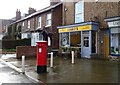
Sunny's Café on Fulford Road
Showing position of Postbox No. YO10 101.
See Image] for postbox.
Image: © JThomas
Taken: 23 Feb 2024
0.04 miles
9
Fulford Road (A19)
Showing position of Postbox No. YO10 101.
See Image] for postbox.
Image: © JThomas
Taken: 23 Feb 2024
0.04 miles
10

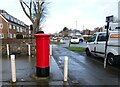
Elizabeth II postbox on Fulford Road
Image: © JThomas
Taken: 23 Feb 2024
0.04 miles