
IMAGES TAKEN NEAR TO
Hartoft Street, YORK, YO10 4BN
Introduction
This page details the photographs taken nearby to Hartoft Street, YO10 4BN by members of the Geograph project.
The Geograph project started in 2005 with the aim of publishing, organising and preserving representative images for every square kilometre of Great Britain, Ireland and the Isle of Man.

There are currently over 7.5m images from over14,400 individuals and you can help contribute to the project by visiting https://www.geograph.org.uk
Image Map
Images are licensed for reuse under creativecommons.org/licenses/by-sa/2.0
Notes
- Clicking on the map will re-center to the selected point.
- The higher the marker number, the further away the image location is from the centre of the postcode.
Image Listing (321 Images Found)
Images are licensed for reuse under creativecommons.org/licenses/by-sa/2.0
Image
Details
Distance
1
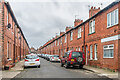
Hartoft Street
Turn of the 19th/20th Centuries terraced housing, first marked on the 1909 25 inch map. It was named after Hartoft in the North Yorkshire Moors, where Isaac Poad, the owner of the land prior to development, was born. For a close up of the blue plaque by the door of no 53, towards the right of the photo see Image
Image: © Ian Capper
Taken: 4 Feb 2023
0.02 miles
2
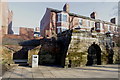
Pikeing Well, New Walk, York
For more details about the Well and New Walk see:
http://www.friendsofnewwalk.org.uk/history.php
Image: © Michael Jagger
Taken: 7 Mar 2010
0.03 miles
3
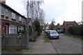
Grange Garth
Looking along Grange Garth near the junction with Rosedale Street.
Image: © DS Pugh
Taken: 6 Dec 2017
0.03 miles
4
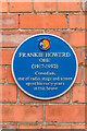
Blue plaque, 53 Hartoft Street
Blue plaque by the door of 53 Hartoft Street commemorating the actor and comedian Frankie Howerd who lived here for the first 2 or so years of his life. For a wider view see Image
Image: © Ian Capper
Taken: 4 Feb 2023
0.04 miles
5
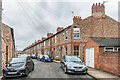
Farndale Street
Turn of the 19th/20th Centuries terraced housing, first marked on the 1909 25 inch map. It was named after Farndale in the North Yorkshire Moors, near to Hartoft where Isaac Poad, the owner of the land prior to development, was born.
Image: © Ian Capper
Taken: 4 Feb 2023
0.05 miles
6
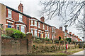
Lastingham Terrace
Turn of the 19th/20th Centuries terrace in three sections, overlooking New Walk alongside the River Ouse and running across the end of Hartoft Street and Farndale Street. It was first marked on the 1909 25 inch map.
Image: © Ian Capper
Taken: 4 Feb 2023
0.05 miles
7

Former well on the banks of the River Ouse
Image: © Gareth James
Taken: 11 Jun 2012
0.05 miles
8
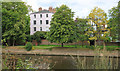
Houses by New Walk, York
The River Ouse is in the foreground.
Image: © Michael Fox
Taken: 7 Jul 2011
0.06 miles
9
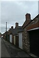
Garages near Hartoft Street
Looking along a row of garages between Hartoft Street and Farndale Street.
Image: © DS Pugh
Taken: 29 Aug 2020
0.06 miles
10

Lastingham Terrace
Turn of the 19th/20th Centuries terrace in three sections, overlooking New Walk alongside the River Ouse and running across the end of Hartoft Street and Farndale Street. It was first marked on the 1909 25 inch map.
Image: © Ian Capper
Taken: 4 Feb 2023
0.06 miles