IMAGES TAKEN NEAR TO
Fewster Way, YORK, YO10 4AD
Introduction
This page details the photographs taken nearby to Fewster Way, YO10 4AD by members of the Geograph project.
The Geograph project started in 2005 with the aim of publishing, organising and preserving representative images for every square kilometre of Great Britain, Ireland and the Isle of Man.

There are currently over 7.5m images from over14,400 individuals and you can help contribute to the project by visiting https://www.geograph.org.uk
Image Map (Loading...)


Getting Data...Please wait
Leaflet Map data © OpenStreetMap
Images are licensed for reuse under creativecommons.org/licenses/by-sa/2.0
Notes
- Clicking on the map will re-center to the selected point.
- The higher the marker number, the further away the image location is from the centre of the postcode.
Image Listing (1057 Images Found)
Images are licensed for reuse under creativecommons.org/licenses/by-sa/2.0
Image
Details
Distance
1
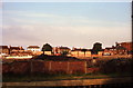
Redfern National Glassworks site during redevelopment
The houses on Fishergate can be seen in the distance.
To the right of the picture is the Rialto, Mecca or Cats Wisker's (night club), it was later used as a bingo hall.
Image: © Michael Jagger
Taken: Unknown
0.02 miles
2

Temporary cycle lane
A temporary cycle lane has been set up along Fishergate and over Castle Mills Bridge in response to the coronavirus (covid-19) outbreak. This section of road/bridge is dual carriageway leading to a busy roundabout. One lane has now been given over to cycling to just before the roundabout to try and help more people cycle.
Image: © DS Pugh
Taken: 16 May 2020
0.02 miles
3
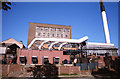
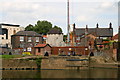
Redfern National Glass Works
The four furnaces can be seen in the middle of the picture, originally the flues had their own smoke stacks, later these were channelled to the main chimney to the right hand side.
To the left of the furnaces are the oil fuel tanks, barges from Whitakers in Hull would fuel the factory, the barges would be heavily laden and travel slowly, as they sailed up the river they would cause the river level to drop as they approached and cause a "mini tsunami" as they passed by.
for more details see:
www.whitakertankers.com
Image: © Michael Jagger
Taken: Unknown
0.03 miles
4
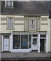
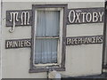
T M Oxtoby & Son
Originally, 'T M Oxtoby & Son Printers Paperhangers Decorators,' now available as a hair salon.
Image: © Dave Pickersgill
Taken: 10 Feb 2014
0.03 miles
5
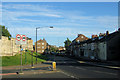
Fishergate, York
The city walls can be seen on the left. Fishergate heads off east towards Fulford and York Race Course.
Image: © Kevin Gordon
Taken: 16 Jul 2008
0.03 miles
6
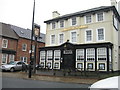
T.M.Oxtoby shopfront
The shopfront of T.M.Oxtoby, in York; the ground floor is now a hairdressers.
Image: © Dave Pickersgill
Taken: 5 Dec 2011
0.03 miles
8
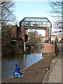
The Foss flood barrage
The River Foss has always had flooding problems along its lower course through York because of Ouse floodwater backing up the smaller tributary. This problem was dealt with in 1988 with the erection of this barrage.
Image: © Gordon Hatton
Taken: 8 Feb 2009
0.04 miles
9
Fishergate Tower
From St George's Field this view of Fishergate Tower on Piccadilly has until recently been obscured by buildings in between the Masons Arms on the right and those at Brownie Dyke on the left. Redevelopment of the site is under way and may obscure the view again.
Image: © David Rogers
Taken: 30 Jun 2008
0.04 miles
10
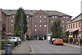
Novotel Hotel, York
One of York's rather bland modern hotel buildings. At least this one is out of sight and not next to some historic edifice. Practical rather than pretty.
Image: © Gordon Hatton
Taken: 8 Feb 2009
0.04 miles