IMAGES TAKEN NEAR TO
Lawrence Square, YORK, YO10 3FG
Introduction
This page details the photographs taken nearby to Lawrence Square, YO10 3FG by members of the Geograph project.
The Geograph project started in 2005 with the aim of publishing, organising and preserving representative images for every square kilometre of Great Britain, Ireland and the Isle of Man.

There are currently over 7.5m images from over14,400 individuals and you can help contribute to the project by visiting https://www.geograph.org.uk
Image Map (Loading...)


Getting Data...Please wait
Leaflet Map data © OpenStreetMap
Images are licensed for reuse under creativecommons.org/licenses/by-sa/2.0
Notes
- Clicking on the map will re-center to the selected point.
- The higher the marker number, the further away the image location is from the centre of the postcode.
Image Listing (259 Images Found)
Images are licensed for reuse under creativecommons.org/licenses/by-sa/2.0
Image
Details
Distance
1
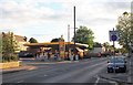
Petrol station on Lawrence Street, York
Viewed from the junction with Bull Lane.
Image: © Bob Embleton
Taken: 4 Jul 2012
0.06 miles
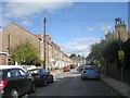
3
Nicholas Gardens - Lawrence Street
Image: © Betty Longbottom
Taken: 29 Aug 2011
0.07 miles

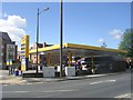
5

Jet garage
The second Yorkshire Marathon having started from the University is seen on Lawrence Street as it heads into the city.
Image: © DS Pugh
Taken: 12 Oct 2014
0.08 miles
6
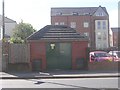
Electricity Substation - Lawrence Street
Image: © Betty Longbottom
Taken: 29 Aug 2011
0.08 miles
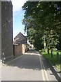
8

Rain on Heslington Road
Looking along Heslington Road on a wet evening.
Image: © DS Pugh
Taken: 28 Feb 2022
0.09 miles
10
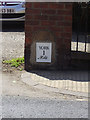
Old Milestone by the A1079, Lawrence Street, York
Metal plate attached to stone post by the A1079, in parish of YORK (YORK District), Lawrence Street, by No. 134, in brick pillar with large white ball on top, on South side of road. York plate, erected by the York to Kexby Bridge & Grimston to Stonedale End turnpike trust in the 19th century.
Inscription reads:-
YORK
1
Mile
Carved benchmark on brick pillar to right of plate.
City of York HER.
HER Number: MYO4270 https://www.heritagegateway.org.uk/Gateway/Results_Single.aspx?uid=MYO4270&resourceID=1003
Milestone Society National ID: YN_YODR01.
Image: © C Minto
Taken: 24 Jan 2009
0.10 miles