IMAGES TAKEN NEAR TO
Pagham Close, WOLVERHAMPTON, WV9 5RD
Introduction
This page details the photographs taken nearby to Pagham Close, WV9 5RD by members of the Geograph project.
The Geograph project started in 2005 with the aim of publishing, organising and preserving representative images for every square kilometre of Great Britain, Ireland and the Isle of Man.

There are currently over 7.5m images from over14,400 individuals and you can help contribute to the project by visiting https://www.geograph.org.uk
Image Map
Images are licensed for reuse under creativecommons.org/licenses/by-sa/2.0
Notes
- Clicking on the map will re-center to the selected point.
- The higher the marker number, the further away the image location is from the centre of the postcode.
Image Listing (95 Images Found)
Images are licensed for reuse under creativecommons.org/licenses/by-sa/2.0
Image
Details
Distance
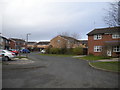
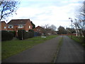
1
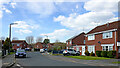
Leybourne Crescent in Pendeford, Wolverhampton
Looking north-west from the junction with Newcott Close.
Image: © Roger Kidd
Taken: 8 Apr 2023
0.05 miles
2
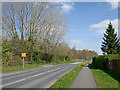
The Droveway in Pendeford north-west of Oxley, Wolverhampton
Looking north-west towards Fordhouses. There is extensive 1970s housing on the right, and further ahead off to the left, covering the area formerly occupied by Wolverhampton Municipal Airport. There is some pleasant heathland and woodland open to the public off to the left here (in Staffordshire). https://www.geograph.org.uk/photo/7453984
See the 1960s map in this https://www.ukairfieldguide.net/airfields/Wolverhampton-Airport )
Image: © Roger Kidd
Taken: 8 Apr 2023
0.07 miles
3
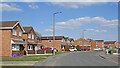
Leybourne Crescent in Pendeford, Wolverhampton
Looking north-east from the junction near Tiffany Lane (off to the right).
Image: © Roger Kidd
Taken: 8 Apr 2023
0.08 miles
4

The Droveway in Pendeford north-west of Oxley, Wolverhampton
Looking north-west towards Fordhouses. There is extensive 1970s housing on the right, and further ahead off to the left, covering the area formerly occupied by Wolverhampton Municipal Airport. There is some pleasant heathland and woodland open to the public off to the left here (in Staffordshire). https://www.geograph.org.uk/photo/7453984
See the 1960s map in this https://www.ukairfieldguide.net/airfields/Wolverhampton-Airport )
Image: © Roger Kidd
Taken: 8 Apr 2023
0.10 miles
5
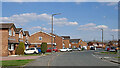
Leybourne Crescent in Pendeford, Wolverhampton
Looking east from near the junction with Tiffany Lane (off to the right).
Image: © Roger Kidd
Taken: 8 Apr 2023
0.10 miles
6
Tiffany Lane, Pendeford
Seen from Ryhope Walk.
Image: © Richard Vince
Taken: 8 Dec 2018
0.11 miles
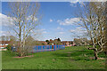
7
Pendeford Park by Weyhill Close in Wolverhampton
This is an attractively landscaped linear public park with many groups of trees, a games court for basketball/handball and a children's playground.
The housing estates here between the Shropshire Union and Staffordshire and Worcestershire canals are on former Wolverhampton Municipal Airport (closed 31 December 1970) land.
Image: © Roger Kidd
Taken: 8 Apr 2023
0.11 miles
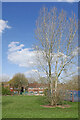
8
Games court in Pendeford Park, Wolverhampton
Looking north-east towards housing in Weyhill Close and Newcott Close.
This attractively landscaped linear public park includes many groups of trees, a games court* and a children's playground. The housing estates at Pendeford between the Shropshire Union and Staffordshire and Worcestershire Canal are on former Wolverhampton Municipal Airport (closed 31 December 1970) land.
* not marked out well, could be used for basketball or handball.
Image: © Roger Kidd
Taken: 8 Apr 2023
0.12 miles
9
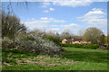
Parkland by Weyhill Close in Pendeford, Wolverhampton
Pendeford Park, looking north-west towards Wehill Close and The Droveway.
This attractively landscaped linear public park includes many groups of trees, a basketball/handball court and a children's playground. The housing estates at Pendeford between the Shropshire Union and Staffordshire and Worcestershire Canal are on former Wolverhampton Municipal Airport (closed 31 December 1970) land.
Image: © Roger Kidd
Taken: 8 Apr 2023
0.13 miles
10
Ryhope Walk, Pendeford
A public footpath and cycle track through the estate, seen passing Tebworth Close (left).
Image: © Richard Vince
Taken: 8 Dec 2018
0.13 miles