IMAGES TAKEN NEAR TO
Tebworth Close, WOLVERHAMPTON, WV9 5QX
Introduction
This page details the photographs taken nearby to Tebworth Close, WV9 5QX by members of the Geograph project.
The Geograph project started in 2005 with the aim of publishing, organising and preserving representative images for every square kilometre of Great Britain, Ireland and the Isle of Man.

There are currently over 7.5m images from over14,400 individuals and you can help contribute to the project by visiting https://www.geograph.org.uk
Image Map
Images are licensed for reuse under creativecommons.org/licenses/by-sa/2.0
Notes
- Clicking on the map will re-center to the selected point.
- The higher the marker number, the further away the image location is from the centre of the postcode.
Image Listing (99 Images Found)
Images are licensed for reuse under creativecommons.org/licenses/by-sa/2.0
Image
Details
Distance
1
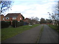
Ryhope Walk, Pendeford
A public footpath and cycle track through the estate, seen passing Tebworth Close (left).
Image: © Richard Vince
Taken: 8 Dec 2018
0.04 miles
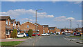
2
Tiffany Lane, Pendeford
Seen from Ryhope Walk.
Image: © Richard Vince
Taken: 8 Dec 2018
0.07 miles
3
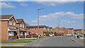
Leybourne Crescent in Pendeford, Wolverhampton
Looking north-east from the junction near Tiffany Lane (off to the right).
Image: © Roger Kidd
Taken: 8 Apr 2023
0.09 miles
4
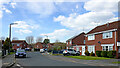
Leybourne Crescent in Pendeford, Wolverhampton
Looking north-west from the junction with Newcott Close.
Image: © Roger Kidd
Taken: 8 Apr 2023
0.09 miles
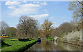
5
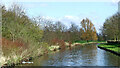
Canalside parkland near Pendeford in Wolverhampton
Looking south-east towards Autherley Junction (with the Staffordshire and Worcestershire Canal, about 980 metres). There is parkland on the left, and the Dovecotes housing estate off to the right.
Image: © Roger Kidd
Taken: 19 Apr 2013
0.09 miles
6
Leybourne Crescent in Pendeford, Wolverhampton
Looking east from near the junction with Tiffany Lane (off to the right).
Image: © Roger Kidd
Taken: 8 Apr 2023
0.10 miles
7
Shropshire Union Canal by Pendeford Park in Wolverhampton
Looking south-west towards Autherley Junction (about 920 metres). Pendeford Park is off to the left.
Image: © Roger Kidd
Taken: 8 Apr 2023
0.10 miles
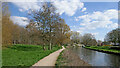
8
Shropshire Union Canal near Pendeford, Wolverhampton
This is the Shropshire Union Canal, looking north-west towards Brewood from near Barnhurst Bridge, No 2. Pendeford Park is on the right. The Dovecotes estate is off to the left, occupying former Barnhurst Farm land.
Image: © Roger Kidd
Taken: 8 Apr 2023
0.10 miles
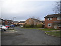
9

Playground View
The view by the Dovecotes Estate, Pendeford, Wolverhampton.
Image: © Gordon Griffiths
Taken: 20 Jan 2022
0.10 miles
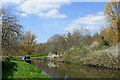
10
Springtime by the canal near Pendeford, Wolverhampton
Looking north-west towards Brewood from the towpath at Barnhurst Bridge, No 2. Pendeford Park is on the right. The Dovecotes housing estate is off to the left, occupying former Barnhurst Farm land.
Forsythia hedges and daffodils add yellow on the left, while the abundant blackthorn blossom gleams in the sun.
Image: © Roger Kidd
Taken: 8 Apr 2023
0.10 miles