IMAGES TAKEN NEAR TO
Penshaw Close, WOLVERHAMPTON, WV9 5NE
Introduction
This page details the photographs taken nearby to Penshaw Close, WV9 5NE by members of the Geograph project.
The Geograph project started in 2005 with the aim of publishing, organising and preserving representative images for every square kilometre of Great Britain, Ireland and the Isle of Man.

There are currently over 7.5m images from over14,400 individuals and you can help contribute to the project by visiting https://www.geograph.org.uk
Image Map
Images are licensed for reuse under creativecommons.org/licenses/by-sa/2.0
Notes
- Clicking on the map will re-center to the selected point.
- The higher the marker number, the further away the image location is from the centre of the postcode.
Image Listing (50 Images Found)
Images are licensed for reuse under creativecommons.org/licenses/by-sa/2.0
Image
Details
Distance
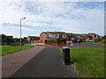
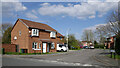
1
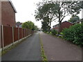
Ryhope Walk
The view in Pendeford, Wolverhampton.
Image: © Gordon Griffiths
Taken: 28 Sep 2020
0.06 miles
2
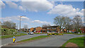
The Droveway in Pendeford, Wolverhampton
Looking east at the roundabout junction with Blaydon Road (off to the right).
Image: © Roger Kidd
Taken: 8 Apr 2023
0.07 miles
3
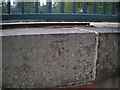
OS benchmark - Pendeford, The Droveway
An OS cutmark, dating from 1982, cut onto the parapet wall of a bridge carrying The Droveway over a pedestrian subway; it was originally levelled at 103.993m above Ordnance Datum Newlyn.
Image: © Richard Law
Taken: 18 Oct 2016
0.09 miles
4
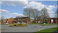
The Droveway roundabout in Pendeford, Wolverhampton
Blaydon Road leads off to the right.
Image: © Roger Kidd
Taken: 8 Apr 2023
0.09 miles
5
The Droveway Scene
The view at Pendeford, Wolverhampton.
Image: © Gordon Griffiths
Taken: 28 Sep 2020
0.10 miles
7
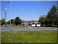
Bus turning circle, Pendeford
This large turning circle, located close to Pendeford's district centre (out of frame to the right), was constructed for the extension of bus services to the estate in the early 1980s. For many years, Pendeford was served by circular services that called in to the turning circle without terminating. However, route 4 (from Springhill via Wolverhampton city centre and Rakegate) now terminates here, while buses on route 6 do a short double run here from the Droveway on their way between the city centre and Wobaston. In this picture, a 4 is laying over (left) while a 6 passes around it.
Image: © Richard Vince
Taken: 4 Jun 2013
0.14 miles
8
Haywain Close in Pendeford, Wolverhampton
Looking east-north-east from Leybourne Crescent.
Image: © Roger Kidd
Taken: 8 Apr 2023
0.14 miles
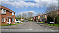
9
Haywain Close in Pendeford, Wolverhampton
Looking north-east from Leybourne Crescent.
Image: © Roger Kidd
Taken: 8 Apr 2023
0.15 miles
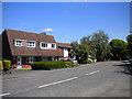
10
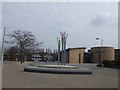
Church and Branch Library
Refurbished public space next to new church building,library and school.
Image: © John M
Taken: 24 Mar 2007
0.15 miles