IMAGES TAKEN NEAR TO
Talaton Close, WOLVERHAMPTON, WV9 5LR
Introduction
This page details the photographs taken nearby to Talaton Close, WV9 5LR by members of the Geograph project.
The Geograph project started in 2005 with the aim of publishing, organising and preserving representative images for every square kilometre of Great Britain, Ireland and the Isle of Man.

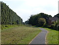
There are currently over 7.5m images from over14,400 individuals and you can help contribute to the project by visiting https://www.geograph.org.uk
Image Map
Images are licensed for reuse under creativecommons.org/licenses/by-sa/2.0
Notes
- Clicking on the map will re-center to the selected point.
- The higher the marker number, the further away the image location is from the centre of the postcode.
Image Listing (75 Images Found)
Images are licensed for reuse under creativecommons.org/licenses/by-sa/2.0
Image
Details
Distance
1
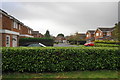
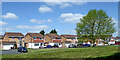
Kerridge Close
Part of a large area of new housing at Pendeford.
Image: © Bill Boaden
Taken: 10 Nov 2016
0.03 miles
2
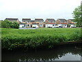
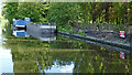
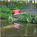
Waterside Way, Pendeford, Wolverhampton
The water in question is the Staffs & Worcs canal.
Image: © Christine Johnstone
Taken: 11 May 2022
0.03 miles
3
Houses in Kerridge Close, Pendeford
A suburb on the north-west edge of Wolverhampton.
Image: © Christine Johnstone
Taken: 11 May 2022
0.04 miles
4
Staffs and Worcestershire View
The view up the Staffordshire and Worcestershire Canal at Pendeford.
Image: © Gordon Griffiths
Taken: 9 Jun 2020
0.04 miles
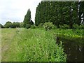
5
Path next to the Staffordshire and Worcestershire Canal
Image: © Mat Fascione
Taken: 18 Aug 2016
0.05 miles
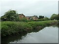
6
Waterside Way houses in Pendeford, Wolverhampton
Looking north-west from the canal, open parkland and housing estates at Pendeford were developed on the former Wolverhampton Municipal Airport.
Image: © Roger Kidd
Taken: 14 May 2016
0.05 miles
7
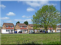
Houses in Pendeford in Wolverhampton
Looking north-west from the canal, open parkland and housing estates at Pendeford were developed on the former Wolverhampton Municipal Airport.
Image: © Roger Kidd
Taken: 14 May 2016
0.05 miles
8
Dredging operations near Pendeford in Wolverhampton
Mud dredged from the Staffordshire and Worcestershire Canal is deposited on the canal bank here north of Autherley Junction.
Image: © Roger Kidd
Taken: 14 May 2016
0.06 miles
9
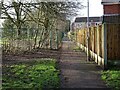
School Gulley
The view from alongside the Staffordshire and Worcestershire Canal up the passageway to the St Pauls C of E Primary School at Pendeford.
Image: © Gordon Griffiths
Taken: 28 Jan 2021
0.06 miles
10
Deep mud by the canal, Wolverhampton
Dredging operations have been in progress on the Staffordshire and Worcestershire Canal north of Autherley Junction.
Image: © Roger Kidd
Taken: 14 May 2016
0.07 miles