IMAGES TAKEN NEAR TO
Westrand, Pendeford Business Park, WOLVERHAMPTON, WV9 5HB
Introduction
This page details the photographs taken nearby to Westrand, Pendeford Business Park, WV9 5HB by members of the Geograph project.
The Geograph project started in 2005 with the aim of publishing, organising and preserving representative images for every square kilometre of Great Britain, Ireland and the Isle of Man.

There are currently over 7.5m images from over14,400 individuals and you can help contribute to the project by visiting https://www.geograph.org.uk
Image Map
Images are licensed for reuse under creativecommons.org/licenses/by-sa/2.0
Notes
- Clicking on the map will re-center to the selected point.
- The higher the marker number, the further away the image location is from the centre of the postcode.
Image Listing (10 Images Found)
Images are licensed for reuse under creativecommons.org/licenses/by-sa/2.0
Image
Details
Distance
1
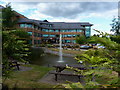
The Birmingham Midshires offices, Pendeford
The modern offices of the B'ham Midshires building society, nowadays a part of the Lloyds Banking group.
Image: © Richard Law
Taken: 5 Jul 2010
0.14 miles
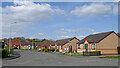
3
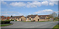
Clematis Drive, Pendeford
Off Armstead Road.
Image: © Richard Vince
Taken: 8 Dec 2018
0.18 miles
5
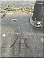
Newton Heath, Berry Brow
Ordnance Survey Rivet Benchmark which at some stage has also been a pivot mark
SJ 8903 9972
Image: © mralrule
Taken: 10 Nov 2021
0.20 miles
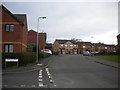
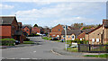
6
Armstead Road in Pendeford, Wolverhampton
Armstead Road is a crescent. This is the western of two junctions with The Droveway.
Image: © Roger Kidd
Taken: 8 Apr 2023
0.20 miles
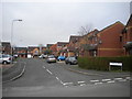
7
Armstead Road in Pendeford, Wolverhampton
Armstead Road is a crescent. This is the western of two junctions with The Droveway.
Image: © Roger Kidd
Taken: 8 Apr 2023
0.21 miles
8
Lavender Close, Pendeford
Off Armstead Road.
Image: © Richard Vince
Taken: 8 Dec 2018
0.21 miles
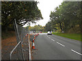
9
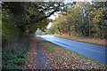
Autumnal colours by Wobaston Road
This is the highest point of the road as it crosses the tongue of land between the Shropshire Union and the Staffordshire & Worcestershire Canals.
Image: © Bill Boaden
Taken: 10 Nov 2016
0.23 miles
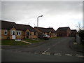
10
The Droveway and Armstead Road in Pendeford, Wolverhampton
This is the westerntern of two junctions between these roads, as Armstead Road is a crescent.
Image: © Roger Kidd
Taken: 8 Apr 2023
0.24 miles