IMAGES TAKEN NEAR TO
Celandine Drive, WOLVERHAMPTON, WV9 5FD
Introduction
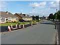
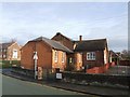
This page details the photographs taken nearby to Celandine Drive, WV9 5FD by members of the Geograph project.
The Geograph project started in 2005 with the aim of publishing, organising and preserving representative images for every square kilometre of Great Britain, Ireland and the Isle of Man.

There are currently over 7.5m images from over14,400 individuals and you can help contribute to the project by visiting https://www.geograph.org.uk
Image Map
Images are licensed for reuse under creativecommons.org/licenses/by-sa/2.0
Notes
- Clicking on the map will re-center to the selected point.
- The higher the marker number, the further away the image location is from the centre of the postcode.
Image Listing (26 Images Found)
Images are licensed for reuse under creativecommons.org/licenses/by-sa/2.0
Image
Details
Distance
1
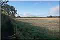
Harvested field by Lower Green
A footpath to Jackson's Bridge runs to the left, in the shadow of the morning sun.
Image: © Bill Boaden
Taken: 10 Nov 2016
0.04 miles
2
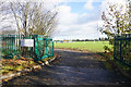
Entrance to Brewood Playing Field
Quite a well-equipped sports facility managed by Brewood & Coven Parish Council.
Image: © Bill Boaden
Taken: 10 Nov 2016
0.08 miles
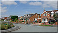
3
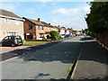
Brook Close, Lower Green
Housing on the northern side of Coven.
Image: © Richard Law
Taken: 16 Jun 2014
0.15 miles
4
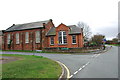
The Old School at Coven on Light Ash Lane
This disused school is beginning to deteriorate, some of the windows have now been broken. There is a modern school behind this one.
Image: © Mick Malpass
Taken: 1 Jan 2012
0.17 miles
5
Oakshaw Close, Lower Green
Housing estate on the northern side of the village of Coven.
Image: © Richard Law
Taken: 16 Jun 2014
0.17 miles
6
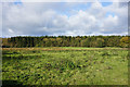
Rough grazing by Standeford Green
Looking across the open space to Somerford Wood.
Image: © Bill Boaden
Taken: 10 Nov 2016
0.18 miles
7
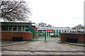
St. Paul's C. of E. School, School Lane Coven
The old school is next door on the left hand side.
Image: © Mick Malpass
Taken: 1 Jan 2012
0.18 miles
8
The old schoolhouse, Coven
The modern school is adjacent.
Image: © John M
Taken: 26 Dec 2007
0.19 miles
9
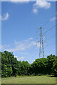
Park and pylon by Lower Green, Coven, Staffordshire
Looking east, the grass had just been cut in this attractive small park area at the north-west end of Coven.
Image: © Roger Kidd
Taken: 14 Jul 2021
0.19 miles
10
Housing in Cinder Hill Lane in Coven, Staffordshire
Near the junction with Brewood Road.
Image: © Roger Kidd
Taken: 14 Jul 2021
0.22 miles