IMAGES TAKEN NEAR TO
Cinder Hill Lane, WOLVERHAMPTON, WV9 5DT
Introduction
This page details the photographs taken nearby to Cinder Hill Lane, WV9 5DT by members of the Geograph project.
The Geograph project started in 2005 with the aim of publishing, organising and preserving representative images for every square kilometre of Great Britain, Ireland and the Isle of Man.

There are currently over 7.5m images from over14,400 individuals and you can help contribute to the project by visiting https://www.geograph.org.uk
Image Map
Images are licensed for reuse under creativecommons.org/licenses/by-sa/2.0
Notes
- Clicking on the map will re-center to the selected point.
- The higher the marker number, the further away the image location is from the centre of the postcode.
Image Listing (57 Images Found)
Images are licensed for reuse under creativecommons.org/licenses/by-sa/2.0
Image
Details
Distance
1
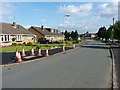
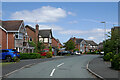
Oakshaw Close, Lower Green
Housing estate on the northern side of the village of Coven.
Image: © Richard Law
Taken: 16 Jun 2014
0.05 miles
2
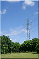
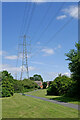
Park and pylon by Lower Green, Coven, Staffordshire
Looking east, the grass had just been cut in this attractive small park area at the north-west end of Coven.
Image: © Roger Kidd
Taken: 14 Jul 2021
0.06 miles
3
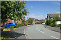
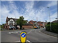
Penkside in Coven, Staffordshire
Looking north-east from the junction with Brewood Road. Some sources call this Penkside Walk. Road signs just call it Penkside.
Image: © Roger Kidd
Taken: 14 Jul 2021
0.07 miles
4
Park and pylon by Lower Green in Coven, Staffordshire
Looking north-east, the grass had just been cut in this attractive small park area at the north-west end of Coven. Some grass areas have been left to nature, and will probably be cut in the autumn.
Image: © Roger Kidd
Taken: 14 Jul 2021
0.07 miles
5
Penkside in Coven, Staffordshire
Looking north-east from the junction with Brewood Road. Some sources call this Penkside Walk. Road signs just call it Penkside.
Image: © Roger Kidd
Taken: 14 Jul 2021
0.07 miles
6
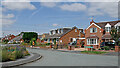
Housing in Cinder Hill Lane in Coven, Staffordshire
Near the junction with Brewood Road.
Image: © Roger Kidd
Taken: 14 Jul 2021
0.09 miles
7
Park by Lower Green in Coven, Staffordshire
The grass had just been cut in this attractive small park area at the north-west end of Coven.
Image: © Roger Kidd
Taken: 14 Jul 2021
0.09 miles
8
Penkside View
The view in Coven, Staffordshire.
Image: © Gordon Griffiths
Taken: 16 Jun 2022
0.09 miles
9
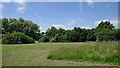
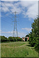
Park near Coven in Staffordshire
Looking north-north-west, the grass had just been cut in this attractive small public park area at the north-western edge of Coven. Some grass areas have been left to nature.
Image: © Roger Kidd
Taken: 14 Jul 2021
0.09 miles
10
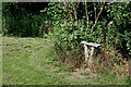
Stump seat
A public footpath by the River Penk passes through a small well-kept park here near Coven in Staffordshire.
Image: © Roger Kidd
Taken: 14 Jul 2021
0.10 miles