IMAGES TAKEN NEAR TO
Wood Avenue, WOLVERHAMPTON, WV9 5DP
Introduction
This page details the photographs taken nearby to Wood Avenue, WV9 5DP by members of the Geograph project.
The Geograph project started in 2005 with the aim of publishing, organising and preserving representative images for every square kilometre of Great Britain, Ireland and the Isle of Man.

There are currently over 7.5m images from over14,400 individuals and you can help contribute to the project by visiting https://www.geograph.org.uk
Image Map (Loading...)


Getting Data...Please wait
Leaflet Map data © OpenStreetMap
Images are licensed for reuse under creativecommons.org/licenses/by-sa/2.0
Notes
- Clicking on the map will re-center to the selected point.
- The higher the marker number, the further away the image location is from the centre of the postcode.
Image Listing (60 Images Found)
Images are licensed for reuse under creativecommons.org/licenses/by-sa/2.0
Image
Details
Distance
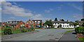
1
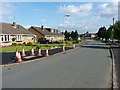
Oakshaw Close, Lower Green
Housing estate on the northern side of the village of Coven.
Image: © Richard Law
Taken: 16 Jun 2014
0.05 miles
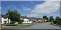
2
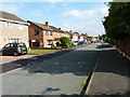
Brook Close, Lower Green
Housing on the northern side of Coven.
Image: © Richard Law
Taken: 16 Jun 2014
0.05 miles
3
Housing in Cinder Hill Lane in Coven, Staffordshire
Near the junction with Brewood Road.
Image: © Roger Kidd
Taken: 14 Jul 2021
0.06 miles
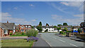
4
Brewood Road in Coven, Staffordshire
Cinder Hill is off to the left.
Image: © Roger Kidd
Taken: 14 Jul 2021
0.06 miles
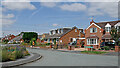
5
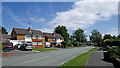
Brewood Road in Coven, Staffordshire
Looking east-north-east from near the roundabout by Poplars Farm Way. Off to the left is Cinder Hill Lane.
Image: © Roger Kidd
Taken: 14 Jul 2021
0.07 miles
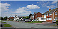
6
Brewood Road in Coven, Staffordshire
Looking north-east from the roundabout by Poplars Farm Way
Image: © Roger Kidd
Taken: 14 Jul 2021
0.07 miles
7
Brewood Road in Coven, Staffordshire
Looking north-west towards the junction with Cinder Hill Lane.
Image: © Roger Kidd
Taken: 14 Jul 2021
0.07 miles
8
Brewood Road in Coven, Staffordshire
Looking south-east from the junction with Cinder Hill Lane. The road meanders through the village and joins the A449 near Cross Green.
Image: © Roger Kidd
Taken: 14 Jul 2021
0.08 miles
9
Brewood Road in Coven, Staffordshire
Looking south-east from near the junction with Cinder Hill Lane. The road meanders through the village and joins the A449 near Cross Green.
Image: © Roger Kidd
Taken: 14 Jul 2021
0.08 miles
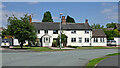
10
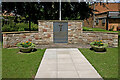
Coven War Memorial in Staffordshire
The war memorial is in the grounds of Coven Memorial Hall. Names of Coven soldiers from both world wars are remembered.
Image: © Roger Kidd
Taken: 14 Jul 2021
0.09 miles