IMAGES TAKEN NEAR TO
Brewood Road, WOLVERHAMPTON, WV9 5DB
Introduction
This page details the photographs taken nearby to Brewood Road, WV9 5DB by members of the Geograph project.
The Geograph project started in 2005 with the aim of publishing, organising and preserving representative images for every square kilometre of Great Britain, Ireland and the Isle of Man.

There are currently over 7.5m images from over14,400 individuals and you can help contribute to the project by visiting https://www.geograph.org.uk
Image Map
Images are licensed for reuse under creativecommons.org/licenses/by-sa/2.0
Notes
- Clicking on the map will re-center to the selected point.
- The higher the marker number, the further away the image location is from the centre of the postcode.
Image Listing (30 Images Found)
Images are licensed for reuse under creativecommons.org/licenses/by-sa/2.0
Image
Details
Distance
1
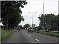
A449 north of Brewood Road roundabouts
The "route confirmatory" sign is interesting. It's unusually placed in the central reservation, rather than on the left of the carriageway. The first mileage to the M6 is correctly in parentheses as that road is accessed indirectly, in this case via the A5 at Gailey.
Image: © J Whatley
Taken: 6 Sep 2010
0.04 miles
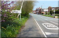
5
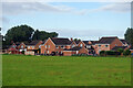
Houses at Coven
Looking across a field towards modern houses on Turnpike Way and Coven Mill Close.
Image: © Stephen McKay
Taken: 30 Aug 2023
0.13 miles
6
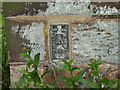
Ordnance Survey flush bracket on Coven Church
Ordnance Survey flush bracket (bench-mark) on Coven Church, serial number S8583. The OS database gives the height of this bench-mark as 105.8119m above mean sea level (Newlyn datum).
Image: © Shantavira
Taken: 2 Jul 2013
0.15 miles
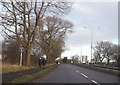
8
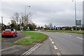
Looking along the A449 towards the M54 and Wolverhampton
Taken from between the two Coven roundabouts. The road to the left goes to Cross Green. The Three Hammers golf complex is between the two roads.
Image: © Mick Malpass
Taken: 1 Jan 2012
0.16 miles
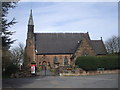
9
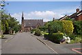
Church Lane, Coven
The church, dedicated to St. Paul, was opened in 1857
Image: © Geoff Pick
Taken: 5 Jun 2006
0.16 miles
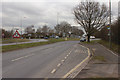
10
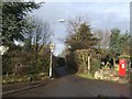
Footpath next to Coven Church
The footpath leads to the new churchyard and village centre.
Image: © John M
Taken: 26 Dec 2007
0.16 miles