IMAGES TAKEN NEAR TO
Port Lane, WOLVERHAMPTON, WV9 5BE
Introduction
This page details the photographs taken nearby to Port Lane, WV9 5BE by members of the Geograph project.
The Geograph project started in 2005 with the aim of publishing, organising and preserving representative images for every square kilometre of Great Britain, Ireland and the Isle of Man.

There are currently over 7.5m images from over14,400 individuals and you can help contribute to the project by visiting https://www.geograph.org.uk
Image Map
Images are licensed for reuse under creativecommons.org/licenses/by-sa/2.0
Notes
- Clicking on the map will re-center to the selected point.
- The higher the marker number, the further away the image location is from the centre of the postcode.
Image Listing (19 Images Found)
Images are licensed for reuse under creativecommons.org/licenses/by-sa/2.0
Image
Details
Distance
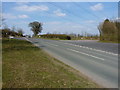
2
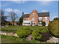
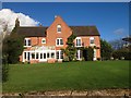
Long Birch Farm
A large & imposing farmhouse between Brewood and Codsall.
Image: © Richard Law
Taken: 6 Apr 2013
0.03 miles
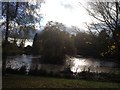
6
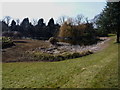
A pool at Long Birch Farm
A large fishpond(?) directly in front of the farmhouse.
Image: © Richard Law
Taken: 6 Apr 2013
0.06 miles
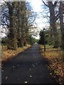
10
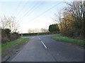
T Junction
The view of the Monarch's Way meeting Port Lane near Bilbrook.
Image: © Gordon Griffiths
Taken: 6 Feb 2020
0.12 miles