IMAGES TAKEN NEAR TO
Harrows Mobile Home Park, School Lane, WOLVERHAMPTON, WV9 5AW
Introduction
This page details the photographs taken nearby to Harrows Mobile Home Park, School Lane, WV9 5AW by members of the Geograph project.
The Geograph project started in 2005 with the aim of publishing, organising and preserving representative images for every square kilometre of Great Britain, Ireland and the Isle of Man.

There are currently over 7.5m images from over14,400 individuals and you can help contribute to the project by visiting https://www.geograph.org.uk
Image Map
Images are licensed for reuse under creativecommons.org/licenses/by-sa/2.0
Notes
- Clicking on the map will re-center to the selected point.
- The higher the marker number, the further away the image location is from the centre of the postcode.
Image Listing (16 Images Found)
Images are licensed for reuse under creativecommons.org/licenses/by-sa/2.0
Image
Details
Distance
1
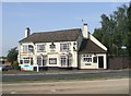
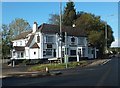
The Harrows Inn on A449 near Coven
Public House on the busy Wolverhampton to Stafford Road.
Image: © John M
Taken: 10 Sep 2006
0.01 miles
2
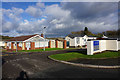
Harrow's Mobile Home Park
Quite a popular format of housing locally. The buildings all appear quite permanently fixed to me.
Image: © Bill Boaden
Taken: 10 Nov 2016
0.01 miles
3
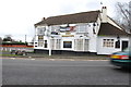
The Harrows on the A449 at Standeford
This pub is under new management, with a for sale sign on it.
Image: © Mick Malpass
Taken: 1 Jan 2012
0.04 miles
4
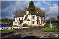
The Harrows Inn, Coven
This has recently become a good destination for beer and cider. It sits at the northern end of School Lane on the A449.
Image: © Bill Boaden
Taken: 10 Nov 2016
0.04 miles
6
The Harrows Lights
The view of the Harrows Inn near Coven at the northern end of School Lane on the A449 Stafford Road.
Image: © Gordon Griffiths
Taken: 19 Nov 2021
0.06 miles
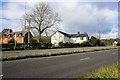
7
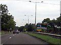
A449 north of Coven
A strand of the high voltage cables which cross the road here is just visible.
Image: © J Whatley
Taken: 6 Sep 2010
0.12 miles
8
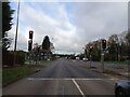
A449 - Standeford traffic lights
The road's earlier course (now Old Stafford Road) comes in from the right, having left in gridsquare SJ9105). See: http://www.geograph.org.uk/photo/2056714
Image: © J Whatley
Taken: 6 Sep 2010
0.12 miles
9
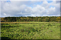
Rough grazing by Standeford Green
Looking across the open space to Somerford Wood.
Image: © Bill Boaden
Taken: 10 Nov 2016
0.14 miles
10
Standeford Farm Cafe
It sits by the A449 and is quite prominent.
Image: © Bill Boaden
Taken: 10 Nov 2016
0.16 miles