IMAGES TAKEN NEAR TO
Heathfields, Heath House Lane, WOLVERHAMPTON, WV8 2HF
Introduction
This page details the photographs taken nearby to Heathfields, Heath House Lane, WV8 2HF by members of the Geograph project.
The Geograph project started in 2005 with the aim of publishing, organising and preserving representative images for every square kilometre of Great Britain, Ireland and the Isle of Man.

There are currently over 7.5m images from over14,400 individuals and you can help contribute to the project by visiting https://www.geograph.org.uk
Image Map
Images are licensed for reuse under creativecommons.org/licenses/by-sa/2.0
Notes
- Clicking on the map will re-center to the selected point.
- The higher the marker number, the further away the image location is from the centre of the postcode.
Image Listing (14 Images Found)
Images are licensed for reuse under creativecommons.org/licenses/by-sa/2.0
Image
Details
Distance
1
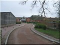
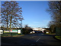
Development at Heath House Farm
The driveway leads up to Heathfields, a barn conversion at Heath House Farm.
Image: © John M
Taken: 30 Dec 2006
0.02 miles
3
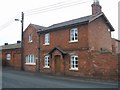
Greenhills Farm
1860 farmhouse on the Wrottesley Park Estate
Image: © John M
Taken: 30 Dec 2006
0.08 miles
4
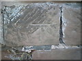
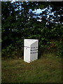
OS benchmark - Codsall, Heath House Lane
An OS cutmark on the sandstone wall just north of Greenhills Farm; originally levelled in 1956 at 124.528m above Ordnance Datum Newlyn.
Image: © Richard Law
Taken: 27 Jul 2016
0.13 miles
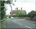
5
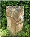
Old Milepost by the A41, Holyhead Road, Codsall Parish
Cast iron post by the A41, in parish of CODSALL (SOUTH STAFFORDSHIRE District), Holyhead Road; 100m East of junction with Wrottesley Park Road, on the verge in front of hedge, on North East side of road. Lathe iron casting, erected by the County Council in the 19th/20th century.
Inscription reads:-
: WOLVERHAMPTON / 4 : : CODSALL : : SHIFNAL 8¼ / WELLINGTON 15 / SHREWSBURY 26 :
Maker:-
: Chas. Lathe, Tipton. :
Grade II Listed. List Entry Number: 1188083
https://historicengland.org.uk/listing/the-list/list-entry/1188083
Milestone Society National ID: ST_WVSR04.
Image: © Mike Faherty
Taken: 9 Jun 2007
0.22 miles
6
Codsall milepost in detail
After a long period of neglect, this milepost on the old coaching route to Chester has just been given a lick of paint. It looks much better for it.
Image: © Richard Law
Taken: 9 Jul 2009
0.22 miles
7
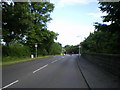
Cross roads and the Codsall milepost in its setting
Wrotteseley Park Road crosses the main A41 at these lights. It's a busy junction, carrying many of the commuters from Perton into Wolverhampton every morning, as well as those who come down the A41 from the M54 and places to the north. The milepost has recently been repainted, after a long period of neglect.
Image: © Richard Law
Taken: 9 Jul 2009
0.23 miles
8
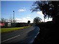
Wergs Hall Road south of Codsall & Wergs Garden Centre
Image: © Richard Vince
Taken: 23 Dec 2017
0.23 miles
9
Entrance to Codsall & Wergs Garden Centre
From Wergs Hall Road. The traffic I kept having to dodge as I walked along Wergs Hall Road was presumably largely generated by the sale of Christmas trees here.
Image: © Richard Vince
Taken: 23 Dec 2017
0.24 miles
10
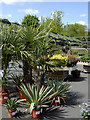
Garden centre shrub area near Codsall, Staffordshire
This shows part of the shrub area in the Codsall and Wergs Garden Centre, which has been under new management since April 2015, but is still worth a visit.
Formerly known as Williams's Nursery, considerable upgrading and expansion has added many extra facilities for the community.
Image: © Roger D Kidd
Taken: 24 May 2016
0.24 miles