IMAGES TAKEN NEAR TO
Harvesters Walk, WOLVERHAMPTON, WV8 1UG
Introduction
This page details the photographs taken nearby to Harvesters Walk, WV8 1UG by members of the Geograph project.
The Geograph project started in 2005 with the aim of publishing, organising and preserving representative images for every square kilometre of Great Britain, Ireland and the Isle of Man.

There are currently over 7.5m images from over14,400 individuals and you can help contribute to the project by visiting https://www.geograph.org.uk
Image Map
Images are licensed for reuse under creativecommons.org/licenses/by-sa/2.0
Notes
- Clicking on the map will re-center to the selected point.
- The higher the marker number, the further away the image location is from the centre of the postcode.
Image Listing (76 Images Found)
Images are licensed for reuse under creativecommons.org/licenses/by-sa/2.0
Image
Details
Distance
1
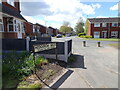
Hedgerow Walk View
The view towards Barnwood Road in Oxley, Wolverhampton.
Image: © Gordon Griffiths
Taken: 6 May 2021
0.10 miles
2
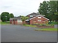
Pendeford Seventh-day Adventist Church
A newish church on Ryefield, which is the main road through the housing estate.
Image: © Richard Law
Taken: 12 Jun 2012
0.12 miles
3
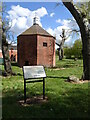
Dovecote View
The view on the Dovecotes Estate, Pendeford, Wolverhampton.
Image: © Gordon Griffiths
Taken: 6 May 2021
0.13 miles
4
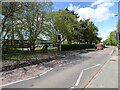
School Crossing
The view of Barnhurst Lane in Wolverhampton by Aldersley High School.
Image: © Gordon Griffiths
Taken: 6 May 2021
0.14 miles
8
Dovecotes Path
The view in Pendeford, Wolverhampton.
Image: © Gordon Griffiths
Taken: 25 Feb 2022
0.16 miles
9
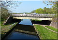
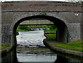
Unusual Bridge
The Turnover Bridge over the Shropshire Union Canal is split for vehicles and pedestrians.
Image: © Gordon Griffiths
Taken: 25 Aug 2008
0.16 miles
10
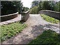
Bridge No 3 on the Shropshire Union Canal at Pendeford
This is an 1830s roving bridge, explained here: Image
It is an unusual roving bridge, shown here Image
Beyond it is the much newer bridge No 3A which carries The Droveway which links housing estates which occupy land on both sides of the canal.
Image: © Roger D Kidd
Taken: 19 May 2009
0.16 miles