IMAGES TAKEN NEAR TO
Cornfield, WOLVERHAMPTON, WV8 1TJ
Introduction
This page details the photographs taken nearby to Cornfield, WV8 1TJ by members of the Geograph project.
The Geograph project started in 2005 with the aim of publishing, organising and preserving representative images for every square kilometre of Great Britain, Ireland and the Isle of Man.

There are currently over 7.5m images from over14,400 individuals and you can help contribute to the project by visiting https://www.geograph.org.uk
Image Map (102 Images)


Getting Data...Please wait
Leaflet Map data © OpenStreetMap
Images are licensed for reuse under creativecommons.org/licenses/by-sa/2.0
Notes
- Clicking on the map will re-center to the selected point.
- The higher the marker number, the further away the image location is from the centre of the postcode.
Image Listing (102 Images Found)
Images are licensed for reuse under creativecommons.org/licenses/by-sa/2.0
Image
Details
Distance
2
Turnover Bridge View
The view of a narrowboat on the Shropshire Union Canal. View of bridge. Image
Image: © Gordon Griffiths
Taken: 1 Jul 2009
0.10 miles
3
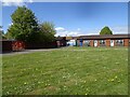
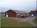
Dovecotes School
The view on the Dovecotes Estate, Pendeford, Wolverhampton.
Image: © Gordon Griffiths
Taken: 6 May 2021
0.12 miles
4
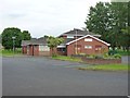
Pendeford Seventh-day Adventist Church
A newish church on Ryefield, which is the main road through the housing estate.
Image: © Richard Law
Taken: 12 Jun 2012
0.13 miles
5
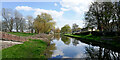
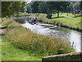
Shropshire Union Canal near Pendeford, Wolverhampton
Looking east-south-east towards Autherley Junction from near Turnover Bridge, No 3. Pendeford Park and extensive housing estates* are off to the left. The Dovecotes estate is off to the right, occupying former Barnhurst Farm land.
* the estates cover most of the land formerly used by Wolverhampton Airport (closed 31 December 1970).
Image: © Roger Kidd
Taken: 8 Apr 2023
0.13 miles
7
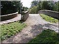
Unusual Bridge
The Turnover Bridge over the Shropshire Union Canal is split for vehicles and pedestrians.
Image: © Gordon Griffiths
Taken: 25 Aug 2008
0.13 miles
8
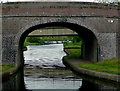
Bridge No 3 on the Shropshire Union Canal at Pendeford
This is an 1830s roving bridge, explained here: Image
It is an unusual roving bridge, shown here Image
Beyond it is the much newer bridge No 3A which carries The Droveway which links housing estates which occupy land on both sides of the canal.
Image: © Roger D Kidd
Taken: 19 May 2009
0.13 miles
9
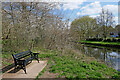
Canal view seat in Pendeford Park, Wolverhampton
Several seats like this were installed in the park during 2022. Some morons have already scratched their names into the paintwork.
This attractively landscaped park is by the Shropshire Union Canal.
Image: © Roger Kidd
Taken: 8 Apr 2023
0.13 miles
10
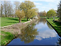
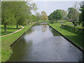
Shropshire Union Canal near Pendeford, Wolverhampton
Looking east-south-east towards Autherley Junction from Turnover Bridge, No 3. Pendeford Park is on the left. The Dovecotes estate is off to the right, occupying former Barnhurst Farm land.
Portrait version: Image]
Image: © Roger Kidd
Taken: 8 Apr 2023
0.13 miles