IMAGES TAKEN NEAR TO
Arps Road, WOLVERHAMPTON, WV8 1SQ
Introduction
This page details the photographs taken nearby to Arps Road, WV8 1SQ by members of the Geograph project.
The Geograph project started in 2005 with the aim of publishing, organising and preserving representative images for every square kilometre of Great Britain, Ireland and the Isle of Man.

There are currently over 7.5m images from over14,400 individuals and you can help contribute to the project by visiting https://www.geograph.org.uk
Image Map
Images are licensed for reuse under creativecommons.org/licenses/by-sa/2.0
Notes
- Clicking on the map will re-center to the selected point.
- The higher the marker number, the further away the image location is from the centre of the postcode.
Image Listing (38 Images Found)
Images are licensed for reuse under creativecommons.org/licenses/by-sa/2.0
Image
Details
Distance
1
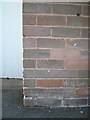
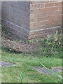
OS benchmark - Codsall, 82 Arps Road
An OS cutmark on the front wall of the house on Arps Road; originally levelled in 1961 at 120.817m above Ordnance Datum Newlyn.
Image: © Richard Law
Taken: 9 Aug 2016
0.07 miles
2

OS benchmark - Codsall, 71 Wilkes Road
An OS cutmark on the corner of the house, levelled at 120.725m above Ordnance Datum Newlyn in 1961.
Image: © Richard Law
Taken: 9 Aug 2016
0.09 miles
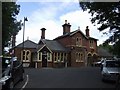
4
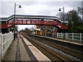
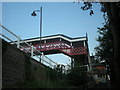
Codsall Station buildings and the pedestrian bridge
The old station buildings are now licensed as a pub, and seemed to be doing a good trade as I passed at lunchtime today.
Image: © Richard Law
Taken: 26 Feb 2010
0.13 miles
5
Trinity Methodist Church, Histons Hill, Codsall
Taken from Histons Drive towards Windsor Gardens.
Image: © A Holmes
Taken: 5 Apr 2007
0.14 miles
6
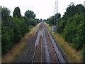
Histons Hill railway bridge.
Codsall Station can just about be seen in the distance.
Image: © A Holmes
Taken: 28 Jul 2008
0.14 miles
9
OS benchmark - Codsall, 16 Wilkes Road
An OS cutmark on the corner of a block of flats on Wilkes Road; originally levelled in 1961 at 119.527m above Ordnance Datum Newlyn.
Image: © Richard Law
Taken: 9 Aug 2016
0.16 miles
10
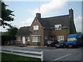
Codsall Railway Station
The station buildings are now used as a public house.
Image: © John M
Taken: 4 Aug 2007
0.17 miles