IMAGES TAKEN NEAR TO
Warner Road, WOLVERHAMPTON, WV8 1SA
Introduction
This page details the photographs taken nearby to Warner Road, WV8 1SA by members of the Geograph project.
The Geograph project started in 2005 with the aim of publishing, organising and preserving representative images for every square kilometre of Great Britain, Ireland and the Isle of Man.

There are currently over 7.5m images from over14,400 individuals and you can help contribute to the project by visiting https://www.geograph.org.uk
Image Map
Images are licensed for reuse under creativecommons.org/licenses/by-sa/2.0
Notes
- Clicking on the map will re-center to the selected point.
- The higher the marker number, the further away the image location is from the centre of the postcode.
Image Listing (44 Images Found)
Images are licensed for reuse under creativecommons.org/licenses/by-sa/2.0
Image
Details
Distance
1
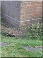
OS benchmark - Codsall, 16 Wilkes Road
An OS cutmark on the corner of a block of flats on Wilkes Road; originally levelled in 1961 at 119.527m above Ordnance Datum Newlyn.
Image: © Richard Law
Taken: 9 Aug 2016
0.06 miles
2

OS benchmark - Codsall, 71 Wilkes Road
An OS cutmark on the corner of the house, levelled at 120.725m above Ordnance Datum Newlyn in 1961.
Image: © Richard Law
Taken: 9 Aug 2016
0.10 miles
3
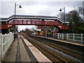
Codsall Station buildings and the pedestrian bridge
The old station buildings are now licensed as a pub, and seemed to be doing a good trade as I passed at lunchtime today.
Image: © Richard Law
Taken: 26 Feb 2010
0.11 miles
6
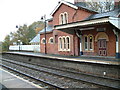
Codsall Station
The station is no longer manned but the buildings contain a Good Pub.
Image: © Hilary Wright
Taken: 29 Oct 2002
0.12 miles
7
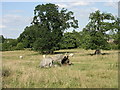
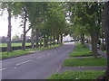
The "nature trail"
... with Springfield house in the background
Image: © Sarah Maidment
Taken: 18 Jul 2005
0.12 miles
8
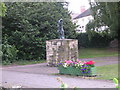
Codsall Square
Statue in Codsall village
Image: © Sarah Maidment
Taken: 18 Jul 2005
0.12 miles
10
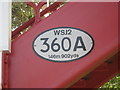
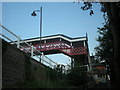
Bridge identification marker
The distance stated i.e. 146 miles 902 yards, is the distance from this bridge to London Euston Station. In the pre-Beeching days when this station served the Western Region the numbers would have been different in that the distance would be measured to London Paddington. To add to the confusion it would also have been stated in Miles & Chains. At least that is what I was informed by railway managers. However, some documentation exists that still maintains the distance measured is to Paddington. Whoever you believe it's still a long walk!
Image: © Row17
Taken: 7 May 2008
0.13 miles