IMAGES TAKEN NEAR TO
Renshaw Road, WOLVERHAMPTON, WV8 1QX
Introduction
This page details the photographs taken nearby to Renshaw Road, WV8 1QX by members of the Geograph project.
The Geograph project started in 2005 with the aim of publishing, organising and preserving representative images for every square kilometre of Great Britain, Ireland and the Isle of Man.

There are currently over 7.5m images from over14,400 individuals and you can help contribute to the project by visiting https://www.geograph.org.uk
Image Map
Images are licensed for reuse under creativecommons.org/licenses/by-sa/2.0
Notes
- Clicking on the map will re-center to the selected point.
- The higher the marker number, the further away the image location is from the centre of the postcode.
Image Listing (8 Images Found)
Images are licensed for reuse under creativecommons.org/licenses/by-sa/2.0
Image
Details
Distance
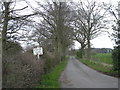
3
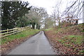
The Wood House
The house stands well back from Donington Lane down this tree lined driveway.
Image: © John M
Taken: 8 Apr 2007
0.21 miles
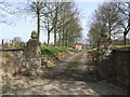
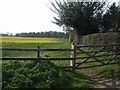
4
Driveway with cattle grid to The Wood House
Image: © Mick Malpass
Taken: 12 Jan 2014
0.21 miles
5
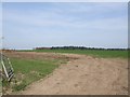
Large open field off Donington Lane
This field is in Staffordshire, the county boundary runs around two edges. Spring Coppice in the distance is in Shropshire. There are no distinctive features or even any signs to mark the county boundary.
Image: © John M
Taken: 8 Apr 2007
0.22 miles
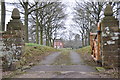
7
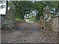
Entrance to The Wood House
Cattle grid and gate piers at the entrance to The Wood House. A different season but the same view as Image] six years ago.
Image: © Philip Halling
Taken: 9 Oct 2019
0.23 miles
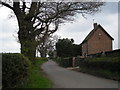
8
View towards Wigmore Wood
Rape field in bloom on the edge of the village.
Image: © John M
Taken: 8 Apr 2007
0.24 miles