IMAGES TAKEN NEAR TO
Whitehouse Lane, WOLVERHAMPTON, WV8 1QG
Introduction
This page details the photographs taken nearby to Whitehouse Lane, WV8 1QG by members of the Geograph project.
The Geograph project started in 2005 with the aim of publishing, organising and preserving representative images for every square kilometre of Great Britain, Ireland and the Isle of Man.

There are currently over 7.5m images from over14,400 individuals and you can help contribute to the project by visiting https://www.geograph.org.uk
Image Map
Images are licensed for reuse under creativecommons.org/licenses/by-sa/2.0
Notes
- Clicking on the map will re-center to the selected point.
- The higher the marker number, the further away the image location is from the centre of the postcode.
Image Listing (7 Images Found)
Images are licensed for reuse under creativecommons.org/licenses/by-sa/2.0
Image
Details
Distance
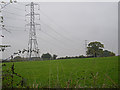
1

Nursery Farm from the footpath to Codsall
Image: © Richard Law
Taken: 22 Jul 2010
0.19 miles
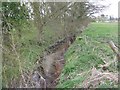
2
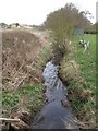
Moat Brook downstream of Codsall footbridge
The Moat Brook flows around the north side of Codsall and is a tributary of the River Penk.
Image: © John M
Taken: 2 Apr 2011
0.20 miles
4
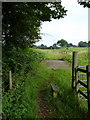
Footbridge over the Moat Brook
The Moat Brook is a tributary of the River Penk.
Image: © Richard Law
Taken: 22 Jul 2010
0.22 miles
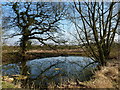
6
Moat Brook upstream of Codsall footbridge
The Moat Brook flows around the north side of Codsall and is a tributary of the River Penk.
Image: © John M
Taken: 2 Apr 2011
0.23 miles
7
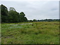
Boggy ground south of Moors Farm, Codsall
A large patch of very wet ground in the valley of the River Penk
Image: © Richard Law
Taken: 22 Jul 2010
0.24 miles