IMAGES TAKEN NEAR TO
Pendrell Close, WOLVERHAMPTON, WV8 1NY
Introduction
This page details the photographs taken nearby to Pendrell Close, WV8 1NY by members of the Geograph project.
The Geograph project started in 2005 with the aim of publishing, organising and preserving representative images for every square kilometre of Great Britain, Ireland and the Isle of Man.

There are currently over 7.5m images from over14,400 individuals and you can help contribute to the project by visiting https://www.geograph.org.uk
Image Map
Images are licensed for reuse under creativecommons.org/licenses/by-sa/2.0
Notes
- Clicking on the map will re-center to the selected point.
- The higher the marker number, the further away the image location is from the centre of the postcode.
Image Listing (29 Images Found)
Images are licensed for reuse under creativecommons.org/licenses/by-sa/2.0
Image
Details
Distance
1
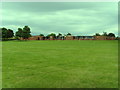
Codsall Middle School
Taken from the sports field to the rear of the building.
Image: © A Holmes
Taken: 12 Jun 2008
0.05 miles
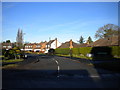
2
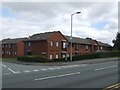
Pendrell Court, sheltered housing
Named after local landowning family. The Pendrells assisted King Charles II in his flight and escape to France following the battle of Worcester.
Image: © John M
Taken: 4 Aug 2007
0.08 miles
3
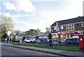
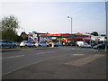
Bilbrook Shops
The view on the Wolverhampton Road in Codsall.
Image: © Gordon Griffiths
Taken: 21 Oct 2021
0.08 miles
4
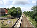
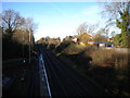
Westbound platform at Bilbrook Station
Towards Shrewsbury. The eastbound platform is on the other side of the road bridge.This was originally just a halt with the main station about a kilometre west at Codsall.
Image: © John M
Taken: 11 Aug 2007
0.08 miles
5
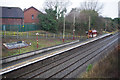
Bilbrook Station
The station at Bilbrook was not opened until 1934 and was originally known as Birches and Bilbrook Halt. The platforms are staggered either side of Birches Bridge; this view shows the down platform (towards Shrewsbury).
Image: © Stephen McKay
Taken: 16 Jan 2018
0.10 miles
6
Down platform, Bilbrook station
Bilbrook station has staggered platforms, located either side of the bridge carrying the road from Wolverhampton to Codsall. This is the view from the bridge towards Shrewsbury, showing the Down platform, occupied by a few passengers awaiting the next train to Shropshire's county town.
Image: © Richard Vince
Taken: 23 Dec 2017
0.10 miles
7
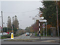
Codsall filling station and road junction
The weirdest priorities and lane discipline apply at this junction, immediately above Bilbrook railway station.
Image: © Richard Law
Taken: 23 Apr 2010
0.12 miles
9
East end of Princes Gardens, Codsall
Seen from Suckling Green Lane.
Image: © Richard Vince
Taken: 23 Dec 2017
0.13 miles
10
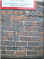
OS benchmark - Bilbrook, station railway bridge
An OS cutmark on the parapet of the railway bridge; originally levelled in 1956 at 123.617m above Ordnance Datum Newlyn.
Image: © Richard Law
Taken: 9 Aug 2016
0.13 miles