IMAGES TAKEN NEAR TO
Joeys Lane, WOLVERHAMPTON, WV8 1JL
Introduction
This page details the photographs taken nearby to Joeys Lane, WV8 1JL by members of the Geograph project.
The Geograph project started in 2005 with the aim of publishing, organising and preserving representative images for every square kilometre of Great Britain, Ireland and the Isle of Man.

There are currently over 7.5m images from over14,400 individuals and you can help contribute to the project by visiting https://www.geograph.org.uk
Image Map
Images are licensed for reuse under creativecommons.org/licenses/by-sa/2.0
Notes
- Clicking on the map will re-center to the selected point.
- The higher the marker number, the further away the image location is from the centre of the postcode.
Image Listing (15 Images Found)
Images are licensed for reuse under creativecommons.org/licenses/by-sa/2.0
Image
Details
Distance
1
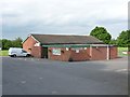
Bilbrook village hall
On the outskirts of Bilbrook, and adjacent to the playing fields.
Image: © Richard Law
Taken: 12 Jun 2012
0.03 miles
2
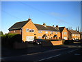
Houses on Pendeford Mill Lane, Bilbrook
Image: © Richard Vince
Taken: 23 Dec 2017
0.08 miles
3
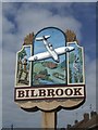
Bilbrook Village Sign
Celebrating the manufacture of the wartime Boulton Paul Defiant night fighter nearby in Pendeford.
The Defiant was built to meet an RAF specification for a 'turret' fighter to intercept formations of unescorted bombers. The weight of the turret and additional crewman together with minimal front armament left the plane vulnerable to frontal attack from the newer fighters.
Image: © John M
Taken: 26 Aug 2012
0.09 miles
4
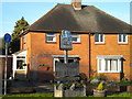
Village sign, Pendeford Mill Lane, Bilbrook
Welcoming those approaching from the east.
Image: © Richard Vince
Taken: 23 Dec 2017
0.09 miles
5
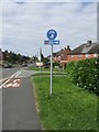
National Cycle Route 81 entering Bilbrook (at Joey's Lane)
Only a short section of the route is signed into Bilbrook. Eventually the route will link Sandwell (joining with Route 5 from Birmingham) and Aberystwyth via Wolverhampton and Shrewsbury.
Image: © John M
Taken: 26 Aug 2012
0.09 miles
6
South end of Joey's Lane, Bilbrook
Seen from Pendeford Mill Lane, near the eastern edge of the village.
Image: © Richard Vince
Taken: 23 Dec 2017
0.09 miles
7
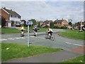
Cyclists on NCN 81
Leaving Joey's Lane beside the Old Village Green.
Image: © John M
Taken: 26 Aug 2012
0.12 miles
8
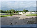
Bilbrook water treatment works
Or sewage works, if you prefer the older term!
Image: © Richard Law
Taken: 12 Jun 2012
0.15 miles
9
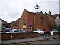
Parish Church of the Holy Cross, Bilbrook
Image: © Richard Law
Taken: 26 Feb 2010
0.18 miles
10
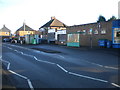
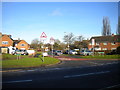
Bus lay by, Pendeford Mill Lane, Bilbrook
Looking rather like a turning circle, but not large enough for turning a bus. I believe this was the terminus of the long withdrawn bus route from Wolverhampton that reached Bilbrook by way of Whitmore Reans, Blakeley Green, and Barnhurst Lane (number 537 in 1983). The timetable case at the stop contained a timetable for routes 88 and 88A from Stafford to Codsall when I visited, but I doubt those routes still exist.
Image: © Richard Vince
Taken: 23 Dec 2017
0.18 miles