IMAGES TAKEN NEAR TO
Tanner Court, WOLVERHAMPTON, WV8 1FB
Introduction
This page details the photographs taken nearby to Tanner Court, WV8 1FB by members of the Geograph project.
The Geograph project started in 2005 with the aim of publishing, organising and preserving representative images for every square kilometre of Great Britain, Ireland and the Isle of Man.

There are currently over 7.5m images from over14,400 individuals and you can help contribute to the project by visiting https://www.geograph.org.uk
Image Map
Images are licensed for reuse under creativecommons.org/licenses/by-sa/2.0
Notes
- Clicking on the map will re-center to the selected point.
- The higher the marker number, the further away the image location is from the centre of the postcode.
Image Listing (10 Images Found)
Images are licensed for reuse under creativecommons.org/licenses/by-sa/2.0
Image
Details
Distance
1
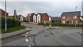
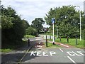
Taylor Wimpey housing on Farran Drive, Codsall
Image: © TCExplorer
Taken: 23 Apr 2023
0.04 miles
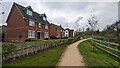
2
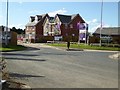
Taylor Wimpey development at Codsall
New houses being built by the builders Taylor Wimpey on a development called Wheatfield Manor at Codsall.
Image: © Philip Halling
Taken: 15 Aug 2017
0.04 miles
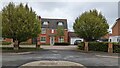
6

55 Farran Drive, Codsall
A Taylor Wimpey development.
Image: © TCExplorer
Taken: 23 Apr 2023
0.14 miles
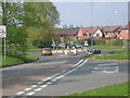
7
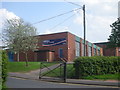
The end of NCN 81 in Bilbrook
The last sign on this short section of NCN 81 beside the school and leisure centre.
Image: © John M
Taken: 26 Aug 2012
0.15 miles
9
2 and 4 Gough Close, Codsall
A Taylor Wimpey development
Image: © TCExplorer
Taken: 23 Apr 2023
0.17 miles
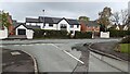
10
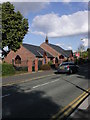
St Christopher's Roman Catholic church, Codsall
The original church was knocked down a few years ago and replaced with this new, purpose-built building.
Image: © Sarah Maidment
Taken: 18 Jul 2005
0.22 miles