IMAGES TAKEN NEAR TO
Nursery Gardens, WOLVERHAMPTON, WV8 1AT
Introduction
This page details the photographs taken nearby to Nursery Gardens, WV8 1AT by members of the Geograph project.
The Geograph project started in 2005 with the aim of publishing, organising and preserving representative images for every square kilometre of Great Britain, Ireland and the Isle of Man.

There are currently over 7.5m images from over14,400 individuals and you can help contribute to the project by visiting https://www.geograph.org.uk
Image Map
Images are licensed for reuse under creativecommons.org/licenses/by-sa/2.0
Notes
- Clicking on the map will re-center to the selected point.
- The higher the marker number, the further away the image location is from the centre of the postcode.
Image Listing (18 Images Found)
Images are licensed for reuse under creativecommons.org/licenses/by-sa/2.0
Image
Details
Distance
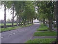
3
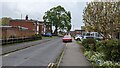
Mature suburban tree
Mature suburban tree on a 1970s housing estate
Image: © TCExplorer
Taken: 23 Apr 2023
0.11 miles
4
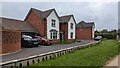
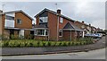
55 Farran Drive, Codsall
A Taylor Wimpey development.
Image: © TCExplorer
Taken: 23 Apr 2023
0.14 miles
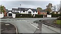
8
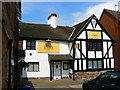
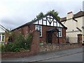
Rajput restaurant, Wolverhampton Road, Codsall
Quaint little building, almost certainly listed, now housing a restaurant and takeaway.
Image: © Brian Robert Marshall
Taken: 25 May 2007
0.20 miles