IMAGES TAKEN NEAR TO
Windsor Road, WOLVERHAMPTON, WV7 3PY
Introduction
This page details the photographs taken nearby to Windsor Road, WV7 3PY by members of the Geograph project.
The Geograph project started in 2005 with the aim of publishing, organising and preserving representative images for every square kilometre of Great Britain, Ireland and the Isle of Man.

There are currently over 7.5m images from over14,400 individuals and you can help contribute to the project by visiting https://www.geograph.org.uk
Image Map
Images are licensed for reuse under creativecommons.org/licenses/by-sa/2.0
Notes
- Clicking on the map will re-center to the selected point.
- The higher the marker number, the further away the image location is from the centre of the postcode.
Image Listing (62 Images Found)
Images are licensed for reuse under creativecommons.org/licenses/by-sa/2.0
Image
Details
Distance
1
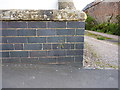
OS benchmark - Albrighton, wall on Station Road
An OS cutmark on a low roadside wall outside one of the houses on the south side of the road; originally levelled at 95.293m above Ordnance Datum Newlyn.
Image: © Richard Law
Taken: 24 May 2015
0.04 miles
2
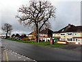
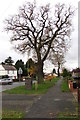
Trees, houses and postbox, Station Road, Albrighton
Viewed from the corner of Albrighton railway station access road. http://www.geograph.org.uk/photo/4755321 The postbox is Victorian. http://www.geograph.org.uk/photo/4755508
Image: © Jaggery
Taken: 1 Dec 2015
0.06 miles
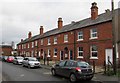
3
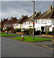
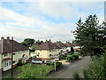
White houses, Station Road, Albrighton
On the north side of Station Road, viewed from near this http://www.geograph.org.uk/photo/4755325 Welcome sign.
Image: © Jaggery
Taken: 1 Dec 2015
0.09 miles
4
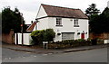
Station Cottage, Albrighton
Station Road house on the corner of Shaw Lane, opposite the access road http://www.geograph.org.uk/photo/4755321 to Albrighton railway station.
Image: © Jaggery
Taken: 1 Dec 2015
0.09 miles
5
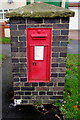
Victorian postbox in a brick pillar, Station Road, Albrighton
Located here. http://www.geograph.org.uk/photo/4755515
Image: © Jaggery
Taken: 1 Dec 2015
0.10 miles
6
Oak on the north side of Station Road, Albrighton
Opposite Shaw Lane. http://www.geograph.org.uk/photo/4755565
Image: © Jaggery
Taken: 1 Dec 2015
0.10 miles
8
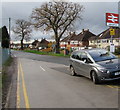
Junction of Station Drive and Station Road, Albrighton
The access road descending from Albrighton railway station joins Station Road.
Ahead for the centre of the village, or turn right for the A41 Albrighton Bypass.
Image: © Jaggery
Taken: 1 Dec 2015
0.10 miles
9
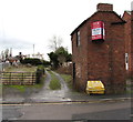
Development site for sale near Albrighton railway station
On December 1st 2015, the For Sale board shows that the development site has planning permission for 8 dwellings. The building is on the corner of Shaw Lane and Station Road, opposite Station Cottage. http://www.geograph.org.uk/photo/4755555
Image: © Jaggery
Taken: 1 Dec 2015
0.11 miles
10
Row of houses, Shaw Lane, Albrighton
Extending for 45 metres towards Station Road.
Image: © Jaggery
Taken: 1 Dec 2015
0.11 miles