IMAGES TAKEN NEAR TO
Botfield Close, WOLVERHAMPTON, WV7 3PT
Introduction
This page details the photographs taken nearby to Botfield Close, WV7 3PT by members of the Geograph project.
The Geograph project started in 2005 with the aim of publishing, organising and preserving representative images for every square kilometre of Great Britain, Ireland and the Isle of Man.

There are currently over 7.5m images from over14,400 individuals and you can help contribute to the project by visiting https://www.geograph.org.uk
Image Map
Images are licensed for reuse under creativecommons.org/licenses/by-sa/2.0
Notes
- Clicking on the map will re-center to the selected point.
- The higher the marker number, the further away the image location is from the centre of the postcode.
Image Listing (59 Images Found)
Images are licensed for reuse under creativecommons.org/licenses/by-sa/2.0
Image
Details
Distance
2
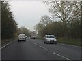
A41 Albrighton bypass at the footpath to Humprheston
Note the short-armed sign on the right of the silver car.
Image: © Peter Whatley
Taken: 17 Jan 2012
0.10 miles
3
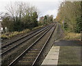
Railway from Albrighton towards Cosford
Viewed from Albrighton railway station looking along the line from Birmingham and Wolverhampton to Shrewsbury via Telford. Next station ahead is Cosford.
Image: © Jaggery
Taken: 1 Dec 2015
0.10 miles
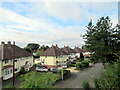
5
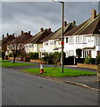
White houses, Station Road, Albrighton
On the north side of Station Road, viewed from near this http://www.geograph.org.uk/photo/4755325 Welcome sign.
Image: © Jaggery
Taken: 1 Dec 2015
0.13 miles
6
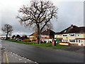
Trees, houses and postbox, Station Road, Albrighton
Viewed from the corner of Albrighton railway station access road. http://www.geograph.org.uk/photo/4755321 The postbox is Victorian. http://www.geograph.org.uk/photo/4755508
Image: © Jaggery
Taken: 1 Dec 2015
0.13 miles
7
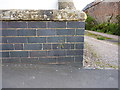
OS benchmark - Albrighton, wall on Station Road
An OS cutmark on a low roadside wall outside one of the houses on the south side of the road; originally levelled at 95.293m above Ordnance Datum Newlyn.
Image: © Richard Law
Taken: 24 May 2015
0.13 miles
8
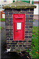
Victorian postbox in a brick pillar, Station Road, Albrighton
Located here. http://www.geograph.org.uk/photo/4755515
Image: © Jaggery
Taken: 1 Dec 2015
0.14 miles
9
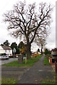
Oak on the north side of Station Road, Albrighton
Opposite Shaw Lane. http://www.geograph.org.uk/photo/4755565
Image: © Jaggery
Taken: 1 Dec 2015
0.14 miles
10
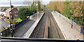
View northwest from Albrighton railway station footbridge
Viewed from here. http://www.geograph.org.uk/photo/4758424 Platform 1 on the right, platform 2 on the left.
This is the route towards Shrewsbury via Telford. Next station ahead is Cosford.
Part of the station is on a bridge. Station Road is on the left.
Image: © Jaggery
Taken: 1 Dec 2015
0.14 miles