IMAGES TAKEN NEAR TO
Newport Road, WOLVERHAMPTON, WV7 3NJ
Introduction
This page details the photographs taken nearby to Newport Road, WV7 3NJ by members of the Geograph project.
The Geograph project started in 2005 with the aim of publishing, organising and preserving representative images for every square kilometre of Great Britain, Ireland and the Isle of Man.

There are currently over 7.5m images from over14,400 individuals and you can help contribute to the project by visiting https://www.geograph.org.uk
Image Map
Images are licensed for reuse under creativecommons.org/licenses/by-sa/2.0
Notes
- Clicking on the map will re-center to the selected point.
- The higher the marker number, the further away the image location is from the centre of the postcode.
Image Listing (9 Images Found)
Images are licensed for reuse under creativecommons.org/licenses/by-sa/2.0
Image
Details
Distance
1
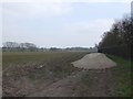
Open farmland near Cosford Camp
Large open field outside the perimeter fence to the married quarters at RAF Cosford.
Image: © John M
Taken: 24 Mar 2007
0.10 miles
3
Sports field and car park at RAF Cosford from A41
Image: © John Firth
Taken: 26 Aug 2015
0.22 miles
5
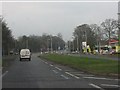
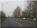
A41 approaching the traffic light crossroads at RAF Cosford
Image: © Peter Whatley
Taken: 17 Jan 2012
0.22 miles
6
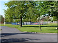
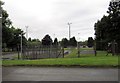
Children's play area at RAF Cosford
This play area is part of the RAF camp within the perimeter fence.
Image: © Richard Law
Taken: 16 May 2010
0.22 miles
7
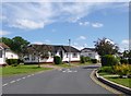
Cosford, Cosford Park
Park homes off Newport Road.
Image: © Mike Faherty
Taken: 30 Jun 2013
0.22 miles
8
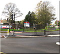
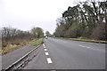
Pelican crossing to RAF Cosford
Across Worcester Road near the A41 Newport Road junction.
Chambers Dictionary states that "pelican" is adapted from "pedestrian light controlled crossing".
Image: © Jaggery
Taken: 1 Dec 2015
0.24 miles
9
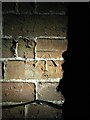
OS benchmark - Cosford, 1 Sydnal Lane
A well preserved OS cutmark on the chnimney breast of no 1, Sydnal Lane; originally levelled at 87.752m above Ordnance Datum Newlyn.
Image: © Richard Law
Taken: 12 Jan 2014
0.24 miles