IMAGES TAKEN NEAR TO
The Smithy, WOLVERHAMPTON, WV7 3LY
Introduction
This page details the photographs taken nearby to The Smithy, WV7 3LY by members of the Geograph project.
The Geograph project started in 2005 with the aim of publishing, organising and preserving representative images for every square kilometre of Great Britain, Ireland and the Isle of Man.

There are currently over 7.5m images from over14,400 individuals and you can help contribute to the project by visiting https://www.geograph.org.uk
Image Map
Images are licensed for reuse under creativecommons.org/licenses/by-sa/2.0
Notes
- Clicking on the map will re-center to the selected point.
- The higher the marker number, the further away the image location is from the centre of the postcode.
Image Listing (52 Images Found)
Images are licensed for reuse under creativecommons.org/licenses/by-sa/2.0
Image
Details
Distance
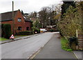
1
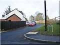
The Smithy
The view from the Kingswood Road in Albrighton.
Image: © Gordon Griffiths
Taken: 7 Feb 2018
0.02 miles
2
From High Street towards Kingswood Road, Albrighton
Viewed past the edge of a former lodge. http://www.geograph.org.uk/photo/4755912
Image: © Jaggery
Taken: 1 Dec 2015
0.03 miles
3
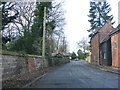
Kingswood Road View
The view along Kingswood Road into Albrighton.
Image: © Gordon Griffiths
Taken: 7 Feb 2018
0.04 miles
4
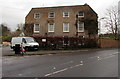
Grade II listed Meeson House, Albrighton
The 18th century 3-storey house at 59 High Street, on the corner of Shaw Lane, was grade II listed in 1984.
Image: © Jaggery
Taken: 1 Dec 2015
0.04 miles
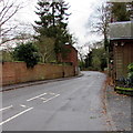
5
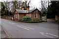
Former lodge, 54 High Street, Albrighton
Former lodge at the entrance to Albrighton Hall.
Image: © Jaggery
Taken: 1 Dec 2015
0.05 miles
6
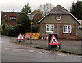
Temporary warning signs at roadworks near an Albrighton corner
The corner of High Street and Shaw Lane on December 1st 2015.
Image: © Jaggery
Taken: 1 Dec 2015
0.05 miles
7
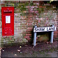
King George V postbox, Shaw Lane, Albrighton
The letters GR date the box to the reign of King George V (May 1910-January 1936).
Image: © Jaggery
Taken: 1 Dec 2015
0.05 miles
8
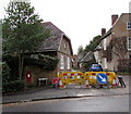
Shaw Lane minor roadworks, Albrighton
Yellow temporary barriers enclose a hole near the southern end of Shaw Lane on December 1st 2015.
Image: © Jaggery
Taken: 1 Dec 2015
0.05 miles
9
Temporary warning signs, Shaw Lane, Albrighton
Temporary signs warn of roadworks ahead and a narrowing of the road on December 1st 2015.
Image: © Jaggery
Taken: 1 Dec 2015
0.06 miles
10
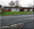
Shaw Lane bungalows, Albrighton
Viewed from the corner of Meeson Close. Originally, bungalow was used in English for a lightly-built house, with a veranda and one storey. In current UK usage it is a convenient word for any one-storey dwelling.
Image: © Jaggery
Taken: 1 Dec 2015
0.08 miles