IMAGES TAKEN NEAR TO
Abney Avenue, WOLVERHAMPTON, WV7 3JZ
Introduction
This page details the photographs taken nearby to Abney Avenue, WV7 3JZ by members of the Geograph project.
The Geograph project started in 2005 with the aim of publishing, organising and preserving representative images for every square kilometre of Great Britain, Ireland and the Isle of Man.

There are currently over 7.5m images from over14,400 individuals and you can help contribute to the project by visiting https://www.geograph.org.uk
Image Map
Images are licensed for reuse under creativecommons.org/licenses/by-sa/2.0
Notes
- Clicking on the map will re-center to the selected point.
- The higher the marker number, the further away the image location is from the centre of the postcode.
Image Listing (114 Images Found)
Images are licensed for reuse under creativecommons.org/licenses/by-sa/2.0
Image
Details
Distance
1
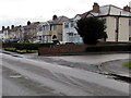
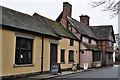
High Street semis, Albrighton
Semi-detached houses on the south side of High Street,
between the junctions of St Mary's Close and Vicarage Fields on the north side.
Image: © Jaggery
Taken: 1 Dec 2015
0.08 miles
2
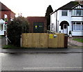
High Street electricity substation, Albrighton
The Western Power Distribution electricity substation is set back 12 metres
from the south side of High Street, behind a wooden fence and locked gate.
Image: © Jaggery
Taken: 1 Dec 2015
0.09 miles
3
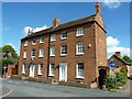
2 & 4 Church Road, Albrighton
2 quite grand, early 19th century terraced houses on Church Road. They attracted a collective Grade II listing https://britishlistedbuildings.co.uk/101367611-2-and-4-church-road-albrighton#.YZYGQ9DP2Uk & https://historicengland.org.uk/listing/the-list/list-entry/1367611 in 1984.
Image: © Richard Law
Taken: 19 Jul 2020
0.09 miles
4
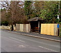
Wooden bus shelter, High Street, Albrighton
Located west of High Street shops. Nearby are the Shrewsbury Arms and St Mary Magdalene church.
A churchyard entrance is on the left.
Image: © Jaggery
Taken: 1 Dec 2015
0.10 miles
6
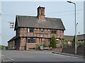
The Shrewsbury Arms, Albrighton
The Shrewsbury Arms in Albrighton is a Grade II listed building. The building dates from the late 15th and early 16th century.
Historic England description
SJ 80 SW ALBRIGHTON C.P. HIGH STREET (south side) 6/16 Shrewsbury Arms 29.9.51 II G.V.
House, now inn. Late C15 or early C16 with later additions and alterations. Half timbered on sandstone and brick plinth with C20 red brick nogging, plain tiled roofs. Hall (fragmentary) and cross- wing type converted. The principal surviving feature is the front to Church Road (cross-wing) of 3 structural bays. Small square panelling to first floor, close studding to ground, short tension braces; con- tinuous moulded jetty to first floor supported on 4 carved brackets, 2 C20 projecting bays with leaded casements underneath, 2 C20 casements to first floor. Prominent central quadripartite chimney with arched dividing rebates and moulded capping on sandstone base. Left hand gable end has close studding to ground floor and square panelling to first; continuation of the first floor jetty on 4 carved brackets (3 replacements, one with linked chain decoration); moulded jetty to attic with lozenge shaped and decorative half timbering above; C20 casements. A fragment of the 'hall' fronts the High Street. Plastered; 2 storeys with C20 casement to first floor and projecting extension with entrance to front. Brick end stack. Sawn-off purlins projecting from gable end show range has been truncated.
Source: https://www.historicengland.org.uk/listing/the-list/list-entry/1367615
Image: © Philip Halling
Taken: 9 Jun 2016
0.10 miles
7
Lyncroft, Albrighton
Looking SSW along Lyncroft from the corner of High Street.
Image: © Jaggery
Taken: 1 Dec 2015
0.10 miles
8
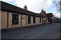
Shrewsbury Arms Hotel, Albrighton
http://www.geograph.org.uk/photo/4898363
Image: © Ian S
Taken: 31 Mar 2016
0.10 miles
9
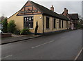
High Street side of the Shrewsbury Arms, Albrighton
The Shrewsbury Arms on the corner of Church Road extends for 40 metres along the west side of High Street.
http://www.geograph.org.uk/photo/4757168 to the oldest part of this Grade II listed building.
Image: © Jaggery
Taken: 1 Dec 2015
0.10 miles
10
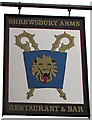
Shrewsbury Arms name sign, Albrighton
Hanging from metal pole at roof level here. http://www.geograph.org.uk/photo/4757168
Image: © Jaggery
Taken: 1 Dec 2015
0.10 miles