1
The Smithy
The view from the Kingswood Road in Albrighton.
Image: © Gordon Griffiths
Taken: 7 Feb 2018
0.11 miles
2
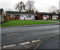
Shaw Lane bungalows, Albrighton
Viewed from the corner of Meeson Close. Originally, bungalow was used in English for a lightly-built house, with a veranda and one storey. In current UK usage it is a convenient word for any one-storey dwelling.
Image: © Jaggery
Taken: 1 Dec 2015
0.11 miles
3
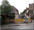
Shaw Lane minor roadworks, Albrighton
Yellow temporary barriers enclose a hole near the southern end of Shaw Lane on December 1st 2015.
Image: © Jaggery
Taken: 1 Dec 2015
0.11 miles
4
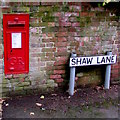
King George V postbox, Shaw Lane, Albrighton
The letters GR date the box to the reign of King George V (May 1910-January 1936).
Image: © Jaggery
Taken: 1 Dec 2015
0.11 miles
5
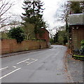
From High Street towards Kingswood Road, Albrighton
Viewed past the edge of a former lodge. http://www.geograph.org.uk/photo/4755912
Image: © Jaggery
Taken: 1 Dec 2015
0.11 miles
6
Grade II listed Meeson House, Albrighton
The 18th century 3-storey house at 59 High Street, on the corner of Shaw Lane, was grade II listed in 1984.
Image: © Jaggery
Taken: 1 Dec 2015
0.11 miles
7
Temporary warning signs at roadworks near an Albrighton corner
The corner of High Street and Shaw Lane on December 1st 2015.
Image: © Jaggery
Taken: 1 Dec 2015
0.12 miles
8
Kingswood Road View
The view along Kingswood Road into Albrighton.
Image: © Gordon Griffiths
Taken: 7 Feb 2018
0.12 miles
9
Field by the railway line, Albrighton
Visible beyond the field, the goalposts of a school playing field: the school is just off the right of the image.
Image: © Christopher Hilton
Taken: 9 Jun 2016
0.12 miles
10
Temporary warning signs, Shaw Lane, Albrighton
Temporary signs warn of roadworks ahead and a narrowing of the road on December 1st 2015.
Image: © Jaggery
Taken: 1 Dec 2015
0.12 miles


